Monday, August 29, 2016
Monday, August 29, 2016 @ 8:00 AM
 The cost of IFR paper charts is expected to rise significantly in the next few months. The increase applies specifically to terminal procedures publications (TPP), which include instrument approach procedures (IAP), departure procedures (DP), standard terminal arrivals (STAR), airport diagrams, as well as takeoff, radar, and alternate minimums.
This will not affect the freely-accessible charts available on iFlightPlanner.com or in iFlightPlanner for iPad. All charts, including VFR Sectionals and Terminal Area Charts (TAC), will continue to be available to all pilots at no cost through iFlightPlanner.
Instrument approaches, SIDs, STARs, airport diagrams and minimums can all be printed from the Documents tab for each airport in the Airport/Facility Directory.
Should you have any questions, please do not hesitate to contact the iFlightPlanner Crew!
Wednesday, August 17, 2016
Wednesday, August 17, 2016 @ 8:00 AM
The FAA has again delayed the implementation of the international flight plan form (ICAO) for all civil domestic flights. Barring another postponement, the FAA will eliminate use of the domestic format flight plan and make the transition to ICAO format in January 2017.
ICAO flight plans contain specific information relating to the proposed flight of an aircraft and controllers use them to provide air traffic services based on the capabilities of each aircraft. Today pilots file flight plans in the U.S. under either the domestic or ICAO format, and the use of one format will simplify the process and align U.S. flight plans with ICAO standards.
This flight planning QuickTip will show you how to easily update your iFlightPlanner aircraft profiles and enjoy a seamless transition to the new ICAO flight plan format when creating and filing flight plans with iFlightPlanner. iFlightPlanner is, and has been ready since this change was first proposed in 2012!
As referenced in the video, there is a lot of aircraft-specific information required to file the ICAO flight plans. However, if you are only flying domestically the FAA requires less ICAO data.
The FAA has issued an informal guidance document that highlights changes specific to the international flight plan form that pertain exclusively to flight within the National Airspace System.

Should you have any questions specific to filing ICAO flight plans in iFlightPlanner, please don't hesitate to contact us!
The iFlightPlanner Crew
PLAN. FLY. LOG.
Thursday, July 21, 2016
Thursday, July 21, 2016 @ 4:01 AM
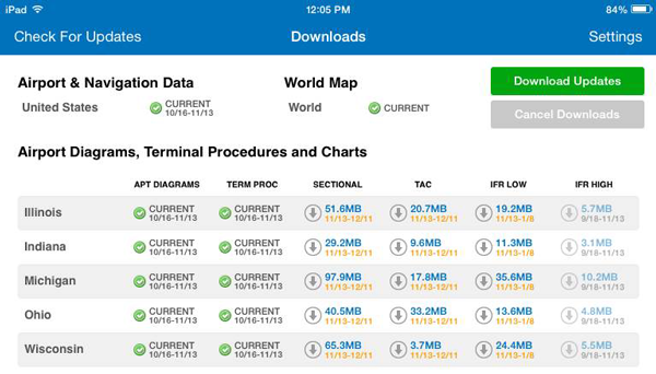
 Official airport, navigation and chart data for the FAA's 56-day cycle beginning 7/21/16 became current today as of 09:01Z. This includes updated georeferenced data for airport diagrams and instrument approach procedures available in iFlightPlanner for iPad.
Anytime you access iFlightPlanner.com or mobile.iFlightPlanner.com you can be confident that you are seeing the most current and accurate data available. To ensure that iFlightPlanner for iPad is current, simply tap "Check for Updates" in the upper-left corner of the Downloads tab. The app will quickly tell you which packages need to be updated!
The iFlightPlanner Crew
PLAN. FLY. LOG.
Thursday, June 23, 2016
Thursday, June 23, 2016 @ 4:01 AM
Official airport, navigation and chart data for the FAA's 28-day cycle beginning 6/23/16 became current today as of 09:01Z. This includes updated georeferenced data for airport diagrams and instrument approach procedures available in iFlightPlanner for iPad.
Anytime you access iFlightPlanner.com or mobile.iFlightPlanner.com you can be confident that you are seeing the most current and accurate data available. To ensure that iFlightPlanner for iPad is current, simply tap "Check for Updates" in the upper-left corner of the Downloads tab. The app will quickly tell you which packages need to be updated!
The iFlightPlanner Crew
PLAN. FLY. LOG.
Thursday, May 26, 2016
Thursday, May 26, 2016 @ 4:01 AM
Official airport, navigation and chart data for the FAA's 56-day cycle beginning 5/26/16 became current today as of 09:01Z. This includes updated georeferenced data for airport diagrams and instrument approach procedures available in iFlightPlanner for iPad.
Anytime you access iFlightPlanner.com or mobile.iFlightPlanner.com you can be confident that you are seeing the most current and accurate data available. To ensure that iFlightPlanner for iPad is current, simply tap "Check for Updates" in the upper-left corner of the Downloads tab. The app will quickly tell you which packages need to be updated!
The iFlightPlanner Crew
PLAN. FLY. LOG.
Monday, May 23, 2016
Monday, May 23, 2016 @ 8:00 AM
iFlightPlanner for iPad users may now download airport and navigation data as well as aeronautical charts, georeferenced airport diagrams and terminal procedures for the FAA Data Cycle that goes into effect on May 26, 2016. Simply tap the button in the upper-left corner of the Downloads tab to "Check For Updates".
Pilots using iFlightPlanner.com or mobile.iFlightPlanner.com from their smartphones will see the iFlightPlanner Cloud automatically make the transition to the new data at 9:01Z on May 26.
Thursday, April 28, 2016
Thursday, April 28, 2016 @ 4:01 AM
Official airport, navigation and chart data for the FAA's 28-day cycle beginning 4/28/16 became current today as of 09:01Z. This includes updated georeferenced data for airport diagrams and instrument approach procedures available in iFlightPlanner for iPad.
Anytime you access iFlightPlanner.com or mobile.iFlightPlanner.com you can be confident that you are seeing the most current and accurate data available. To ensure that iFlightPlanner for iPad is current, simply tap "Check for Updates" in the upper-left corner of the Downloads tab. The app will quickly tell you which packages need to be updated!
The iFlightPlanner Crew
PLAN. FLY. LOG.
Monday, April 25, 2016
Monday, April 25, 2016 @ 8:00 AM
iFlightPlanner for iPad users may now download airport and navigation data as well as aeronautical charts, georeferenced airport diagrams and terminal procedures for the FAA Data Cycle that goes into effect on April 28, 2016. Simply tap the button in the upper-left corner of the Downloads tab to "Check For Updates".
Pilots using iFlightPlanner.com or mobile.iFlightPlanner.com from their smartphones will see the iFlightPlanner Cloud automatically make the transition to the new data at 9:01Z on April 28.
Monday, April 11, 2016
Monday, April 11, 2016 @ 8:00 AM
GPS testing scheduled for April 11-15, 18-23, and 25-29 may result in unreliable or unavailable GPS signals in the Midwest per Flight Advisory GAFC 16-02.
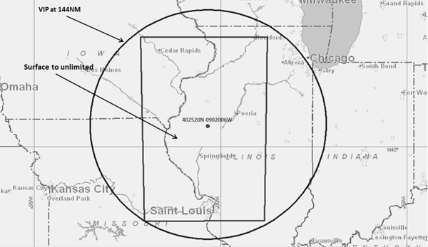
The location of the testing is centered at 402520N/902006W or the Spinner VORTAC (SPI) 321 degree radial at 46NM and will occur at the following dates and times:
- 11–15 APR 16 1300Z – 2100Z
- 18–23 APR 16 1300Z – 2100Z
- 25–29 APR 16 1300Z – 2100Z
The NOTAMs discussed in this advisory may change with little or no notice, and the FAA encourages pilots to check NOTAMs frequently for possible changes prior to operations in the area which will be published at least 24 hours in advance of any GPS tests.
» Flight Advisory GAFC 16-02
Friday, April 8, 2016
Friday, April 8, 2016 @ 8:00 AM
Not planning with an iFlightPlanner Premium or iFlightPlanner Premium Plus membership is likely costing you - using these four simple planning tools will help save you fuel, time, and money every time you fly!
Detailed Aircraft Performance Profiles
iFlightPlanner offers the most detailed aircraft performance profiles of any flight planning solution. Not only can you input performance data by altitude, but as an iFlightPlanner Premium or iFlightPlanner Premium Plus member, you're able to create and plan usingmultiple performance profiles that will maximize your aircraft's range or cruise speed. The flight planner is so robust that it interpolates aircraft performance based on all available data, and gets more precise as you add details to the profile for each altitude.
Do you have performance profiles that you've perfected for your aircraft? Let us know, the iFlightPlanner Crew will be happy to help add it to your account!

Altitude Efficiency Comparison Tool
Leveraging your detailed aircraft performance profiles, iFlightPlanner can compare every altitude (up to your aircraft's maximum) to identify the quickest, and most fuel-efficient altitudes for your flight. Simply click the Compare Altitudes button in the online Flight Wizard or in iFlightPlanner for iPad to discover the fuel savings waiting for you enroute!

Aircraft Fuel Range Mapping
Instantly see if you can reach your destination non-stop, or know when you'll begin burning your predetermined reserve fuel with our fuel range identifiers. The orange marker shows where you'll tap into your reserve, while the red marker indicates the maximum range of your aircraft given your route, aircraft performance, and forecasted winds. Each fuel setting is available when editing an aircraft from your My Aircraft list, allowing the markers to appear on the map automatically for iFlightPlanner Premium and iFlightPlanner Premium Plus members.

Graphical Fuel Price Map Layers
Turn on the fuel price layers in any of our interactive maps, including iFlightPlanner for iPad, to get a look at the most recently reported fuel prices across the country. Each fuel price links to our comprehensive Airport/Facility Directory for each airport, complete with FBO details, runway information, and printable airport diagrams and instrument approach procedures.

Using another EFB but want to switch to iFlightPlanner and take advantage of these great features? Our Competitive Upgrade Program allows you to trade-in your existing subscription and have the time remaining on it added to your new iFlightPlanner Premium or Premium Plus membership.
If you have any questions, please send us a message. We are always happy to help and want you to get the most out of your iFlightPlanner experience!
Thursday, March 31, 2016
Thursday, March 31, 2016 @ 4:01 AM
Official airport, navigation and chart data for the FAA's 56-day cycle beginning 3/31/16 became current today as of 09:01Z. This includes updated georeferenced data for airport diagrams and instrument approach procedures available in iFlightPlanner for iPad.
Anytime you access iFlightPlanner.com or mobile.iFlightPlanner.com you can be confident that you are seeing the most current and accurate data available. To ensure that iFlightPlanner for iPad is current, simply tap "Check for Updates" in the upper-left corner of the Downloads tab. The app will quickly tell you which packages need to be updated!
The iFlightPlanner Crew
PLAN. FLY. LOG.
Monday, March 28, 2016
Monday, March 28, 2016 @ 8:00 AM
iFlightPlanner for iPad users may now download airport and navigation data as well as aeronautical charts, georeferenced airport diagrams and terminal procedures for the FAA Data Cycle that goes into effect on March 31, 2016. Simply tap the button in the upper-left corner of the Downloads tab to "Check For Updates".
Pilots using iFlightPlanner.com or mobile.iFlightPlanner.com from their smartphones will see the iFlightPlanner Cloud automatically make the transition to the new data at 9:01Z on March 31.
Friday, March 18, 2016
Friday, March 18, 2016 @ 8:00 AM
GPS testing scheduled for March 21, 30, and 31 may result in unreliable or unavailable GPS signals on the east coast per Flight Advisory CSG4 GPS 16-01.

The location of the testing is centered at 322655N0793719W or the Charleston VORTAC (CHS) 150 degree radial at 34NM and will occur on March 21 from 1100-1900Z, and March 30-31 from 1100-1700Z.
The NOTAMs discussed in this advisory may change with little or no notice, and the FAA encourages pilots to check NOTAMs frequently for possible changes prior to operations in the area which will be published at least 24 hours in advance of any GPS tests.
» Flight Advisory CSG4 GPS 16-01
Wednesday, March 16, 2016
Wednesday, March 16, 2016 @ 8:00 AM
While all of the information provided in the publication will remain the same, the FAA’s familiar green Airport/Facility Directory is changing its official name with the March 31 editions to the "Chart Supplement" per a Charting Notice dated March 31, 2016.

The newly named supplements for the lower 48 states, Puerto Rico, and the U.S. Virgin Islands will continue to contain complete airport data highlighting navigation, communication, weather sources, runways, obstacles, and other information necessary for safe flight. The FAA said the change will bring the Airport/Facility Directory in line with Interagency Air Cartographic (AICC) 8 specifications for printed products. Additionally, all knowledge tests, literature, and other references will soon reflect the new name, which has already been implemented for the country’s northwest region.
The change will not effect the Airport/Facility Directory available online at iFlightPlanner.com/Airports or in iFlightPlanner for iPad.
Monday, February 29, 2016
Monday, February 29, 2016 @ 8:00 AM
iFlightPlanner for iPad users may now download airport and navigation data as well as aeronautical charts, georeferenced airport diagrams and terminal procedures for the FAA Data Cycle that goes into effect on March 3, 2016. Simply tap the button in the upper-left corner of the Downloads tab to "Check For Updates".
Pilots using iFlightPlanner.com or mobile.iFlightPlanner.com from their smartphones will see the iFlightPlanner Cloud automatically make the transition to the new data at 9:01Z on March 3.
Monday, February 1, 2016
Monday, February 1, 2016 @ 8:00 AM
iFlightPlanner for iPad users may now download airport and navigation data as well as aeronautical charts, georeferenced airport diagrams and terminal procedures for the FAA Data Cycle that goes into effect on February 4, 2016. Simply tap the button in the upper-left corner of the Downloads tab to "Check For Updates".
Pilots using iFlightPlanner.com or mobile.iFlightPlanner.com from their smartphones will see the iFlightPlanner Cloud automatically make the transition to the new data at 9:01Z on February 4.
Friday, January 8, 2016
Friday, January 8, 2016 @ 8:00 AM
The FAA will be applying additional flight restrictions to the Washington, D.C. Special Flight Rules Area (SFRA) and Flight Restricted Zone (FRZ) for President Obama’s State of the Union address on January 12. Click the image for an interactive map of the changes.

Pilots in the Washington, D.C. area are urged to read the flight advisory issued by the FAA, which describes the additional restrictions in more detail.
Thursday, January 7, 2016
Thursday, January 7, 2016 @ 4:01 AM
Official airport, navigation and chart data for the FAA's 28-day cycle beginning 1/7/16 became current today as of 09:01Z. This includes updated georeferenced data for airport diagrams and instrument approach procedures available in iFlightPlanner for iPad.
Anytime you access iFlightPlanner.com or mobile.iFlightPlanner.com you can be confident that you are seeing the most current and accurate data available. To ensure that iFlightPlanner for iPad is current, simply tap "Check for Updates" in the upper-left corner of the Downloads tab. The app will quickly tell you which packages need to be updated!
The iFlightPlanner Crew
PLAN. FLY. LOG.
Monday, January 4, 2016
Monday, January 4, 2016 @ 8:00 AM
iFlightPlanner for iPad users may now download airport and navigation data as well as aeronautical charts, georeferenced airport diagrams and terminal procedures for the FAA Data Cycle that goes into effect on January 7, 2016. Simply tap the button in the upper-left corner of the Downloads tab to "Check For Updates".
Pilots using iFlightPlanner.com or mobile.iFlightPlanner.com from their smartphones will see the iFlightPlanner Cloud automatically make the transition to the new data at 9:01Z on January 7.
Monday, December 21, 2015
Monday, December 21, 2015 @ 8:00 AM
The iFlightPlanner Crew is excited to announce that we will be fully supporting the Bad Elf ADS-B receivers at product launch!
In 2010, Bad Elf brought aviation-grade GPS to the iPad. The Bad Elf GPS receivers became the best selling Apple approved external GPS accessory providing high performance GPS data to location-based iOS applications. Now Bad Elf is announcing their affordable ADS-B weather and traffic receiver with support from Kickstarter.

After five years of portable ADS-B receivers being on the market, less than 10% of pilots are flying with real-time, subscription-free weather and traffic in the cockpit. They cite high price and restricted compatibility as the two main reasons that they have not yet purchased an ADS-B receiver.
With Bad Elf taking a fresh approach and building their ADS-B receiver around open standards, iFlightPlanner is fully on board. We’ve never been a fan of exclusivity and we absolutely love the path that Bad Elf and others are forging with ADS-B device interoperability. Together we recognize that pilots want a choice, and a chance to find the solution that best suits their needs.

The next version of iFlightPlanner for iPad is in the final stages of testing, and we've pushed its release back to include this new opportunity with Bad Elf. Including the to-be-released Bad Elf ADS-B device, iFlightPlanner for iPad will support ADS-B connectivity for nine different manufacturers and at least thirteen different receivers, including both portable devices and certified ADS-B installations.
Be sure to keep an eye on the iFlightPlanner Blog for the latest updates on iFlightPlanner, as well as Kickstarter to learn more about the Bad Elf campaign!
Thursday, December 10, 2015
Thursday, December 10, 2015 @ 4:01 AM
Official airport, navigation and chart data for the FAA's 56-day cycle beginning 12/10/15 became current today as of 09:01Z. This includes updated georeferenced data for airport diagrams and instrument approach procedures available in iFlightPlanner for iPad.
Anytime you access iFlightPlanner.com or mobile.iFlightPlanner.com you can be confident that you are seeing the most current and accurate data available. To ensure that iFlightPlanner for iPad is current, simply tap "Check for Updates" in the upper-left corner of the Downloads tab. The app will quickly tell you which packages need to be updated!
The iFlightPlanner Crew
PLAN. FLY. LOG.
Monday, December 7, 2015
Monday, December 7, 2015 @ 8:00 AM
iFlightPlanner for iPad users may now download airport and navigation data as well as aeronautical charts, georeferenced airport diagrams and terminal procedures for the FAA Data Cycle that goes into effect on December 10, 2015. Simply tap the button in the upper-left corner of the Downloads tab to "Check For Updates".
Pilots using iFlightPlanner.com or mobile.iFlightPlanner.com from their smartphones will see the iFlightPlanner Cloud automatically make the transition to the new data at 9:01Z on December 10.
Thursday, November 12, 2015
Thursday, November 12, 2015 @ 4:01 AM
Official airport, navigation and chart data for the FAA's 28-day cycle beginning 11/12/15 became current today as of 09:01Z. This includes updated georeferenced data for airport diagrams and instrument approach procedures available in iFlightPlanner for iPad.
Anytime you access iFlightPlanner.com or mobile.iFlightPlanner.com you can be confident that you are seeing the most current and accurate data available. To ensure that iFlightPlanner for iPad is current, simply tap "Check for Updates" in the upper-left corner of the Downloads tab. The app will quickly tell you which packages need to be updated!
The iFlightPlanner Crew
PLAN. FLY. LOG.
Monday, November 9, 2015
Monday, November 9, 2015 @ 8:00 AM
 The FAA has announced a new plan to ensure that pilots have all the information they need as the agency phases out world aeronautical charts (WACs), with new Alaska and Caribbean charts being created to fill the gaps.
In an October 29 announcement, the FAA said it will produce an Alaska VFR Wall Planning Chart to help pilots as they plan long-distance flights. The wall chart will show all of Alaska as well as the Canadian territory between Washington State and Alaska. The FAA also will produce two new Caribbean VFR Aeronautical Charts that will provide more coverage than is available with the three WACs they will replace. The scale for the Caribbean charts will be 1 to 1 million.
The new charts should be available in early January 2017, when the existing WACs for those areas expire.
» Read more on AOPA.org
Monday, November 9, 2015 @ 4:01 AM
iFlightPlanner for iPad users may now download airport and navigation data as well as aeronautical charts, georeferenced airport diagrams and terminal procedures for the FAA Data Cycle that goes into effect on November 12, 2015. Simply tap the button in the upper-left corner of the Downloads tab to "Check For Updates".
Pilots using iFlightPlanner.com or mobile.iFlightPlanner.com from their smartphones will see the iFlightPlanner Cloud automatically make the transition to the new data at 9:01Z on November 12.
Thursday, October 15, 2015
Thursday, October 15, 2015 @ 8:00 AM
Official airport, navigation and chart data for the FAA's 56-day cycle beginning 10/15/15 became current today as of 09:01Z. This includes updated georeferenced data for airport diagrams and instrument approach procedures available in iFlightPlanner for iPad.
Anytime you access iFlightPlanner.com or mobile.iFlightPlanner.com you can be confident that you are seeing the most current and accurate data available. To ensure that iFlightPlanner for iPad is current, simply tap "Check for Updates" in the upper-left corner of the Downloads tab. The app will quickly tell you which packages need to be updated!
The iFlightPlanner Crew
PLAN. FLY. LOG.
Monday, October 12, 2015
Monday, October 12, 2015 @ 8:00 AM
iFlightPlanner for iPad users may now download airport and navigation data as well as aeronautical charts, georeferenced airport diagrams and terminal procedures for the FAA Data Cycle that goes into effect on October 15, 2015. Simply tap the button in the upper-left corner of the Downloads tab to "Check For Updates".
Pilots using iFlightPlanner.com or mobile.iFlightPlanner.com from their smartphones will see the iFlightPlanner Cloud automatically make the transition to the new data at 9:01Z on October 15.
Friday, October 9, 2015
Friday, October 9, 2015 @ 8:00 AM
 Andy Matthews is a competitive innovator who is not afraid of following his passion. He’s not afraid of heights either, and has the pilot’s license to prove it. After spending nine years as a professional golfer, Andy co-founded iFlightPlanner, an Ann Arbor-based company that provides aviation weather and cloud-based flight planning resources for private and corporate pilots. He recently met with the University of Michigan Center for Entrepreneurship’s Eric Bacyinski to talk about how taking risks has taken him around the world, and why he turned his passion for aviation into a startup.
» Risk Without Fear: How U-M Alum Andy Matthews Jumped from Links to Aviation
Monday, October 5, 2015
Monday, October 5, 2015 @ 8:00 AM
Icom America recently introduced their new A220 VHF air band radio for the avionics market, featuring enhanced squelch control, a bright white display, and easy installation.

The IC-A220 builds upon the manufacturer's celebrated A210 panel mount transceiver. Like its predecessor, the Mil-Spec A220 features easy "flip-flop" channel selection to switch between main and standby channels. It also retains the A210's intercom functions and GPS memory functionality (when connected to an external receiver).
The Icom IC-A220 features a large, bright organic light emitting diode (OLED) display with white key backlighting, and an auto-dimmer function adjusts the OLED's brightness for ideal daytime or nighttime operation. It also has one-action squelch operation and automatic/manual squelch control, and offers a D-SUB 25 connector in its back panel promotes a flexible and easy installation.

Innovative features found in this next generation air band panel mount transceiver are why more pilots trust Icom as the one you add before flight. For a complete list of highlights and detailed features, visit Icom's online product page for the IC-A220 or download the complete product brochure.
Wednesday, August 26, 2015
Wednesday, August 26, 2015 @ 8:00 AM
iFlightPlanner has incorporated Hangar Network’s real estate data into its flight planning tools. Now hangars and airport properties that are for sale, lease or available as transient space are viewable as an interactive layer in all of iFlightPlanner’s web-based mapping interfaces. An industry first, these new tools allow pilots to see all the space available at airports along their route of flight.
Whether buying or selling a hangar, seeking a home for a flight department or searching for transient space during an upcoming trip, iFlightPlanner and Hangar Network have brought together the best of both products to showcase all the real estate available along a flight route. Listings are updated by Hangar Network daily, allowing iFlightPlanner to provide one-click access to current, complete listing details and property information.

“Hangar Network strives to be the central resource for the aviation and airport real estate industry. Our mission is to change the way that aviators, industry professionals and the world connect to aviation real estate. By partnering with iFlightPlanner, we are revolutionizing the industry and demonstrating our ongoing commitment to finding new, better ways to navigate the aviation real estate market,” said Iver Retrum, co-founder and manager, Hangar Network. “By making this connection we are taking the first step toward creating a system where, in addition to exposing an airport’s long-term real estate options, aviators are able to communicate and make transient hangar accommodations available on a real-time basis.”
“Partnering with Hangar Network has allowed us to add even more industry-leading functionality to iFlightPlanner. Whether pilots are simply viewing our freely accessible aviation charts or planning a detailed cross-country flight and filing flight plans, finding the airport real estate to meet their needs at home or on the go has never been easier,” said Andy Matthews, co-founder & director of business development for iFlightPlanner.
Pilots may choose to overlay any combination of Hangar Network listings along their route of flight by selecting their preferred property types from the Map Layers menu found in the upper-left corner of all iFlightPlanner’s online maps. Available hangars, land, airport residential space, tie down space and warehouse/flex space are all shown.

When zoomed out, iFlightPlanner’s intelligent zoom functionality will show a summarized total of listings at each airport, and when zoomed in, or by clicking the “Zoom to Satellite View” button, users can see the precise location of each listing on the airfield with color-coded identifiers indicating their respective availability. In addition to the graphical map layer, all of Hangar Network’s listings are also available through iFlightPlanner’s comprehensive Airport/Facility Directory on the Hangars & Properties tab available for each airport.

To add an airport property listing to Hangar Network for display on iFlightPlanner, visit http://www.HangarNetwork.com/Signup to create an account!
About Hangar Network
Hangar Network is the leading resource for connecting individuals to aviation real estate. Their map-centric listing service provides unmatched access to a diverse range of airport related real estate. Hangar Network has changed the way aviators, industry professionals and the world connect to aviation real estate. In addition to a state-of-the-art listing service, Hangar Network also provides users and subscribers with the latest industry news, expert advice and industry happenings through its social media channels, newsletter and blog. For more information, please visit www.HangarNetwork.com.
Thursday, August 20, 2015
Thursday, August 20, 2015 @ 4:01 AM
Official airport, navigation and chart data for the FAA's 56-day cycle beginning 8/20/15 became current today as of 09:01Z. This includes updated georeferenced data for airport diagrams and instrument approach procedures available in iFlightPlanner for iPad.
Anytime you access iFlightPlanner.com or mobile.iFlightPlanner.com you can be confident that you are seeing the most current and accurate data available. To ensure that iFlightPlanner for iPad is current, simply tap "Check for Updates" in the upper-left corner of the Downloads tab. The app will quickly tell you which packages need to be updated!
The iFlightPlanner Crew
PLAN. FLY. LOG.
Wednesday, August 19, 2015
Wednesday, August 19, 2015 @ 8:00 AM
Celebrate National Aviation Day with a number of all-new planning functions you'll find on our freely accessible aviation charts interface, iFlightPlanner.com/AviationCharts!
- Pressing enter key when the cursor is in route box plans the route
- Added "GS" parameter for groundspeed in the Permalink
- Clicking a waypoint ID in the Nav Log will zoom to that location on the map
- Clicking Total Distance or Total Time in the Nav Log zooms out to the full route
- Mousing over a route line now highlights the corresponding Nav Log segment
- Waypoints may be reordered in the Nav Log by dragging and dropping
- Most changes now result in an immediate route recalculation
- Previous map type, route and groundspeed are now restored via cookies

All of these upgrades came as the direct result of feedback we received from pilots all across the country, and they have helped set the foundation for an exciting new partnership that we will be announcing very soon, so stay tuned!
Monday, August 17, 2015
Monday, August 17, 2015 @ 8:00 AM
iFlightPlanner for iPad users may now download airport and navigation data as well as aeronautical charts, georeferenced airport diagrams and terminal procedures for the FAA Data Cycle that goes into effect on August 20, 2015. Simply tap the button in the upper-left corner of the Downloads tab to "Check For Updates".
Pilots using iFlightPlanner.com or mobile.iFlightPlanner.com from their smartphones will see the iFlightPlanner Cloud automatically make the transition to the new data at 9:01Z on August 20.
Monday, August 3, 2015
Monday, August 3, 2015 @ 8:00 AM
On July 31 we launched the latest enhancements to iFlightPlanner.com. As part of this update, we introduced updated maps functionality that is part of our ongoing effort to unify the user experiences found online and in iFlightPlanner for iPad. The most noticeable feature change is the Location menu that is revealed when clicking anywhere on the map, allowing a lat/lon, airport, navaid or custom location to be added to a route with a single click. This same menu will also allow you to access iFlightPlanner's graphical airspace functionality by clicking the adjacent Airspace button.

The nearby airports, navaids and custom locations can also be accessed by rubberbanding any existing waypoint or route segment to a new location. This new flight planning functionality, aside from mirroring the usability of iFlightPlanner for iPad, is aimed at making the flight planning processes simpler and more efficient.
Should you have any questions about using this, or any other feature found in iFlightPlanner, please don't hesitate to contact us!
The iFlightPlanner Crew
PLAN. FLY. LOG.
Thursday, July 23, 2015
Thursday, July 23, 2015 @ 4:01 AM
Official airport, navigation and chart data for the FAA's 28-day cycle beginning 7/23/15 became current today as of 09:01Z. This includes updated georeferenced data for airport diagrams and instrument approach procedures available in iFlightPlanner for iPad.
Anytime you access iFlightPlanner.com or mobile.iFlightPlanner.com you can be confident that you are seeing the most current and accurate data available. To ensure that iFlightPlanner for iPad is current, simply tap "Check for Updates" in the upper-left corner of the Downloads tab. The app will quickly tell you which packages need to be updated!
The iFlightPlanner Crew
PLAN. FLY. LOG.
Monday, July 20, 2015
Monday, July 20, 2015 @ 8:00 AM
iFlightPlanner for iPad users may now download airport and navigation data as well as aeronautical charts, georeferenced airport diagrams and terminal procedures for the FAA Data Cycle that goes into effect on July 23, 2015. Simply tap the button in the upper-left corner of the Downloads tab to "Check For Updates".
Pilots using iFlightPlanner.com or mobile.iFlightPlanner.com from their smartphones will see the iFlightPlanner Cloud automatically make the transition to the new data at 9:01Z on July 23.
Wednesday, July 15, 2015
Wednesday, July 15, 2015 @ 8:00 AM
 This free 32-page booklet is an absolute must if you're flying an aircraft to Oshkosh. The AirVenture 2015 NOTAM outlines all arrival/departure procedures, radio frequencies, Wittman Regional Airport (KOSH) details, and much more. Although many of the procedures are similar to previous years, there are updates in nearly every area to enhance safety, efficiency, and convenience for the thousands of airplanes expected at the World's Greatest Aviation Celebration.
The EAA AirVenture NOTAM is required reading and should be part of every pilot's preflight preparation. Remember to print your arrival and departure signs before your trip and fly safe!
The iFlightPlanner Crew
PLAN. FLY. LOG.
Monday, July 13, 2015
Monday, July 13, 2015 @ 8:00 AM
iFlightPlanner's freely accessible Aviation Charts now feature the ability to quickly retrieve a certified weather brief and file a flight plan. Tasks previously reserved for our Flight Wizard are now a single click away!

Thanks to a recent feature request in the iFlightPlanner Forums we were able to enhance one of our most frequented online resources and improve the experience of planning with iFlightPlanner. As always, should you have any questions or would like to share an idea for a new feature, please don't hesitate to contact us! We look forward to hearing from you.
The iFlightPlanner Crew
PLAN. FLY. LOG.
Wednesday, July 1, 2015
Wednesday, July 1, 2015 @ 8:00 AM
We are pleased to report that the bug in iOS 8.3 that blocked GPS position data from Bluetooth GPS devices has been resolved with the release of iOS 8.4.
The problem affected the XGPS150, XGPS160 and XGPS170 from Dual as well as Bluetooth GPS devices from other manufacturers such as Bad Elf and Garmin. Our in-house testing has confirmed that the devices are now working properly.

We want to thank our membership for your patience during the past three months as we know how frustrating this was. Should you have any questions please do not hesitate to contact us, we are always happy to help!
Monday, June 29, 2015
Monday, June 29, 2015 @ 8:00 AM
With the most recent update to LiveATC.net, web-based listeners now have direct access to iFlightPlanner's free online aviation charts and weather overlays. Simply click through to the Airport Info, VFR Sectional or IFR Low Enroute charts in the facility details.

Thursday, June 25, 2015
Thursday, June 25, 2015 @ 4:01 AM
Official airport, navigation and chart data for the FAA's 56-day cycle beginning 6/25/15 became current today as of 09:01Z. This includes updated georeferenced data for airport diagrams and instrument approach procedures available in iFlightPlanner for iPad.
Anytime you access iFlightPlanner.com or mobile.iFlightPlanner.com you can be confident that you are seeing the most current and accurate data available. To ensure that iFlightPlanner for iPad is current, simply tap "Check for Updates" in the upper-left corner of the Downloads tab. The app will quickly tell you which packages need to be updated!
The iFlightPlanner Crew
PLAN. FLY. LOG.
Monday, June 22, 2015
Monday, June 22, 2015 @ 8:00 AM
iFlightPlanner for iPad users may now download airport and navigation data as well as aeronautical charts, georeferenced airport diagrams and terminal procedures for the FAA Data Cycle that goes into effect on June 25, 2015. Simply tap the button in the upper-left corner of the Downloads tab to "Check For Updates".
Pilots using iFlightPlanner.com or mobile.iFlightPlanner.com from their smartphones will see the iFlightPlanner Cloud automatically make the transition to the new data at 9:01Z on June 25.
Friday, June 12, 2015
Friday, June 12, 2015 @ 8:00 AM
 On June 13, 2015 Think Global Flight will begin it's around the world flight of adventure, promoting education and inspiring more than 20,000 students in 21 countries across the globe.
Among those expressing their support are Think Global Flight Ambassadors Astronaut Dr. Buzz Aldrin and Voyager pilot Dick Rutan. Buzz Aldrin will join the crew on most of their journey. Captain Judy Rice will be flying the donated Citation Mustang with Ardwin Freight President Edwin Sahakian to classroom presentations with students and media during their scheduled stops along the route.
Think Global Flight provides opportunities serving as a global, inaugural experience for the exploration of career options and pathways in the aviation and aerospace industries growing Science, Technology, Engineering, and Mathematics (STEM) awareness. TGF is recognized by the Federal Aviation Administration and U.S. Department of Education for real-world applications to STEM.
» ThinkGlobalFlight.org
Wednesday, June 10, 2015
Wednesday, June 10, 2015 @ 8:00 AM
During Apple's Worldwide Developer Conference (WWDC) keynote yesterday, Apple announced iOS 8.4 which is expected to be available by June 30th and include a fix for the bug affecting external GPS receiver accessories.

Although everyone, including the elves at Bad Elf, had hoped for a 8.3.1 update or 8.4 release to launch much sooner there is confidence in the fact that a firm date has finally been announced.
» More at BadElf.com
Thursday, May 28, 2015
Thursday, May 28, 2015 @ 4:01 AM
Official airport, navigation and chart data for the FAA's 28-day cycle beginning 5/28/15 became current today as of 09:01Z. This includes updated georeferenced data for airport diagrams and instrument approach procedures available in iFlightPlanner for iPad.
Anytime you access iFlightPlanner.com or mobile.iFlightPlanner.com you can be confident that you are seeing the most current and accurate data available. To ensure that iFlightPlanner for iPad is current, simply tap "Check for Updates" in the upper-left corner of the Downloads tab. The app will quickly tell you which packages need to be updated!
The iFlightPlanner Crew
PLAN. FLY. LOG.
Monday, May 25, 2015
Monday, May 25, 2015 @ 8:00 AM
iFlightPlanner for iPad users may now download airport and navigation data as well as aeronautical charts, georeferenced airport diagrams and terminal procedures for the FAA Data Cycle that goes into effect on May 5, 2015. Simply tap the button in the upper-left corner of the Downloads tab to "Check For Updates".
Pilots using iFlightPlanner.com or mobile.iFlightPlanner.com from their smartphones will see the iFlightPlanner Cloud automatically make the transition to the new data at 9:01Z on May 28.
Thursday, May 14, 2015
Thursday, May 14, 2015 @ 8:00 AM
iFlightPlanner has just learned that the Federal Aviation Administration awarded a new contract for the Direct User Access Terminal Service (DUATS) to Computer Sciences Corporation (CSC) and Lockheed Martin. This contract to provide self-serve, automated flight services was previously held by CSC and Data Transformation Corporation (DTC).
Know that we will continue to leverage our connection to the National Airspace System (NAS) through CSC DUATS, however additional functionality offered by Lockheed Martin as a result of the DUATS II contract will be explored.
» PRESS RELEASE: CSC DUATS, Lockheed Martin Awarded DUATS II Contract
Having built the entirety of iFlightPlanner.com, mobile.iFlightPlanner.com and iFlightPlanner for iPad in-house, we have the ultimate in flexibility when unique situations like this arise. You can be confident that any functionality enhancements will be communicated to you as soon as they are released.
If you have been away from iFlightPlanner or know of a fellow pilot who is looking for the best free alternative to the services offered on the DUATS platform, look no further than iFlightPlanner. Our freely-accessible flight planning tools for the web and iPad are simply unmatched!
The iFlightPlanner Crew
PLAN. FLY. LOG
Thursday, April 30, 2015
Thursday, April 30, 2015 @ 4:01 AM
Official airport, navigation and chart data for the FAA's 56-day cycle beginning 4/30/15 became current today as of 09:01Z. This includes updated georeferencing data for airport diagrams and instrument approach procedures available in iFlightPlanner for iPad.
Anytime you access iFlightPlanner.com or mobile.iFlightPlanner.com you can be confident that you are seeing the most current and accurate data available. To ensure that iFlightPlanner for iPad is current, simply tap "Check for Updates" in the upper-left corner of the Downloads tab. The app will quickly tell you which packages need to be updated!
The iFlightPlanner Crew
PLAN. FLY. LOG.
Wednesday, April 29, 2015
Wednesday, April 29, 2015 @ 8:00 AM
With the latest releases to AeroWeather Lite and AeroWeather Pro for iPhone and iPad, users will now have direct access to iFlightPlanner's Airport/Facility Directory and freely accessible VFR and IFR Low charts!

AeroWeather provides current and precise weather conditions for airports worldwide, searchable by either name or ICAO code and is a great companion to iFlightPlanner.com, mobile.iFlightPlanner.com and iFlightPlanner for iPad for pilots needing weather information outside of the United States.
Monday, April 27, 2015
Monday, April 27, 2015 @ 8:00 AM
iFlightPlanner recently announced the availability of new functionality that allows pilots to create and save flight plan files for use in the new GTN 600 and 700-series avionics by Garmin.
This innovative technology eliminates the need for pilots to manually enter complex routes. Instead, pilots can simply save a GFP file from iFlightPlanner.com to a compatible SD Card, then follow the step-by-step instructions found in the Garmin Pilot’s Guide for their particular unit to activate or store the route files.
 “iFlightPlanner is very excited to be the first flight planning resource offering file export capabilities for use in the Garmin GTN series of avionics,” said Andy Matthews, iFlightPlanner’s Co-Founder & Director of Business Development. “Safety, usability and flight planning efficiency are at the core of every new feature we develop and we believe our membership will find this technology to be an incredible asset to their flying.”
iFlightPlanner has been a leader in flight plan file creation since it first introduced this type of functionality for its members in 2012, with GFP compatibility building on iFlightPlanner’s existing FPL flight plan file creation for Garmin’s G1000 and 430/530 avionics packages. Collectively iFlightPlanner now supports five (5) different file formats – Garmin GFP and FPL, GPX, GPX for AvMap and the FMS flight plan file format used in the popular X-Plane Flight Simulator by Laminar Research.
The GFP format is compatible with the GTN 625, 635, 650, 725 and 750 models running software version 5.10 or later and requires an iFlightPlanner Premium or Premium Plus membership. It should also be noted that the GFP must be saved to a folder named “FPL” on the root of the SD Card as that is where the GTN models will look for the files.
iFlightPlanner Premium memberships with route export capabilities start at just $9.99/month and include access to iFlightPlanner’s cloud-based flight planning technology across all of its platforms, including iFlightPlanner for iPad. iFlightPlanner Free memberships are available with no obligation and allow pilots to leverage much of iFlightPlanner’s web-based technology with limited, read-only functionality on the iPad. A one-time, 30-day free trial to iFlightPlanner Premium is available via the App Store.
The iFlightPlanner Crew will be in Lakeland, FL at SUN ‘n FUN from April 21–26 in Booths D-011 and D-012. Pilots are encouraged to stop by for their personal demonstration or visit http://www.iFlightPlanner.com for more information.
