Monday, July 25, 2016
Monday, July 25, 2016 @ 8:00 AM
The FAR-FC and FAR-AMT books are available and shipping now from ASA. The FAR/AIM (which includes new 14 CFR Parts 48 and 107 pertaining to both manned aircraft and remote pilot operations) will begin shipping on August 10.

The ASA FAR/AIM Series books are indexed and show clearly-marked changes since the last release for quick reference.
Friday, July 22, 2016
Friday, July 22, 2016 @ 8:00 AM
 The July/August 2016 issue of FAA Safety Briefing focuses on the world of student pilots and airmen-in-training. This issue provides tips and resources for success in initial pilot certification. It also explores the new Airman Certification Standards (ACS) which begins rolling out this summer. The ACS lists the standards for what an applicant needs to know, consider, and do in order to pass both the knowledge test and the practical test for a certificate or rating.
Get your fully compatible PDF, ePub for iOS, Nook and Android, or MOBI file for your Kindle of this issue at faa.gov!
Monday, June 13, 2016
Monday, June 13, 2016 @ 8:00 AM
 In an effort to spur adoption of ADS-B avionics ahead of the 2020 equipment mandate, the FAA announced a rebate program for owners of U.S.-registered piston airplanes — but as you might guess, there’s a catch.
Once the incentive program goes into effect in September, the first 20,000 aircraft owners to equip with ADS-B Out avionics will receive the cash incentive worth $500. It must be for new ADS-B avionics and not software updates or ADS-B gear in new airplanes. The program will run for one year or until the FAA distributes the 20,000 rebates.
» More from FLYING
Monday, April 18, 2016
Monday, April 18, 2016 @ 8:00 AM
The Aircraft Owners and Pilots Association’s (AOPA) Air Safety Institute has released Personal Minimum Contracts for both VFR and IFR pilots. The program helps pilots document personal minimums to become the basis for a contract pilots make with themselves.

“Personal Minimum Contracts will help VFR and IFR pilots take some of the guess work out of tough decisions,” said George Perry, senior vice president, AOPA Air Safety Institute. “Instead of relying on a hunch or feelings, having a written contract that pilots keep with them becomes a promise to themselves, their passengers, and their families. This contract will give pilots a safety tool to help them make smart decisions when it matters most.”
After determining which contract would apply, pilots are encouraged to review the questions with their CFI, update the information regularly, and keep a copy with flight planning materials for reference.
Friday, April 8, 2016
Friday, April 8, 2016 @ 8:00 AM
Not planning with an iFlightPlanner Premium or iFlightPlanner Premium Plus membership is likely costing you - using these four simple planning tools will help save you fuel, time, and money every time you fly!
Detailed Aircraft Performance Profiles
iFlightPlanner offers the most detailed aircraft performance profiles of any flight planning solution. Not only can you input performance data by altitude, but as an iFlightPlanner Premium or iFlightPlanner Premium Plus member, you're able to create and plan usingmultiple performance profiles that will maximize your aircraft's range or cruise speed. The flight planner is so robust that it interpolates aircraft performance based on all available data, and gets more precise as you add details to the profile for each altitude.
Do you have performance profiles that you've perfected for your aircraft? Let us know, the iFlightPlanner Crew will be happy to help add it to your account!

Altitude Efficiency Comparison Tool
Leveraging your detailed aircraft performance profiles, iFlightPlanner can compare every altitude (up to your aircraft's maximum) to identify the quickest, and most fuel-efficient altitudes for your flight. Simply click the Compare Altitudes button in the online Flight Wizard or in iFlightPlanner for iPad to discover the fuel savings waiting for you enroute!

Aircraft Fuel Range Mapping
Instantly see if you can reach your destination non-stop, or know when you'll begin burning your predetermined reserve fuel with our fuel range identifiers. The orange marker shows where you'll tap into your reserve, while the red marker indicates the maximum range of your aircraft given your route, aircraft performance, and forecasted winds. Each fuel setting is available when editing an aircraft from your My Aircraft list, allowing the markers to appear on the map automatically for iFlightPlanner Premium and iFlightPlanner Premium Plus members.

Graphical Fuel Price Map Layers
Turn on the fuel price layers in any of our interactive maps, including iFlightPlanner for iPad, to get a look at the most recently reported fuel prices across the country. Each fuel price links to our comprehensive Airport/Facility Directory for each airport, complete with FBO details, runway information, and printable airport diagrams and instrument approach procedures.

Using another EFB but want to switch to iFlightPlanner and take advantage of these great features? Our Competitive Upgrade Program allows you to trade-in your existing subscription and have the time remaining on it added to your new iFlightPlanner Premium or Premium Plus membership.
If you have any questions, please send us a message. We are always happy to help and want you to get the most out of your iFlightPlanner experience!
Wednesday, January 6, 2016
Wednesday, January 6, 2016 @ 8:00 AM
 The January/February 2016 issue of FAA Safety Briefing focuses on the FAA’s new Compliance Philosophy and what its foundational concepts mean to the general aviation community. Articles in this issue discuss how the agency and aviation community can identify a problem in the NAS, use the most effective tools to correct that problem, and monitor the situation to be sure it stays fixed into the future.
Feature articles include:
- How do You do Safety? – Developing Sound Risk-Based Decision Making Practices in Aviation
- In Data We Trust: Does Flight Data Monitoring Hold the Key to Improving GA Safety?
- Compliance Philosophy with General Aviation – FAA’s Evolving Culture on Aviation Safety
Get your fully compatible PDF, ePub for iOS, Nook and Android, or MOBI file for your Kindle of this issue at faa.gov!
Monday, December 21, 2015
Monday, December 21, 2015 @ 8:00 AM
The iFlightPlanner Crew is excited to announce that we will be fully supporting the Bad Elf ADS-B receivers at product launch!
In 2010, Bad Elf brought aviation-grade GPS to the iPad. The Bad Elf GPS receivers became the best selling Apple approved external GPS accessory providing high performance GPS data to location-based iOS applications. Now Bad Elf is announcing their affordable ADS-B weather and traffic receiver with support from Kickstarter.

After five years of portable ADS-B receivers being on the market, less than 10% of pilots are flying with real-time, subscription-free weather and traffic in the cockpit. They cite high price and restricted compatibility as the two main reasons that they have not yet purchased an ADS-B receiver.
With Bad Elf taking a fresh approach and building their ADS-B receiver around open standards, iFlightPlanner is fully on board. We’ve never been a fan of exclusivity and we absolutely love the path that Bad Elf and others are forging with ADS-B device interoperability. Together we recognize that pilots want a choice, and a chance to find the solution that best suits their needs.

The next version of iFlightPlanner for iPad is in the final stages of testing, and we've pushed its release back to include this new opportunity with Bad Elf. Including the to-be-released Bad Elf ADS-B device, iFlightPlanner for iPad will support ADS-B connectivity for nine different manufacturers and at least thirteen different receivers, including both portable devices and certified ADS-B installations.
Be sure to keep an eye on the iFlightPlanner Blog for the latest updates on iFlightPlanner, as well as Kickstarter to learn more about the Bad Elf campaign!
Monday, November 9, 2015
Monday, November 9, 2015 @ 8:00 AM
 The FAA has announced a new plan to ensure that pilots have all the information they need as the agency phases out world aeronautical charts (WACs), with new Alaska and Caribbean charts being created to fill the gaps.
In an October 29 announcement, the FAA said it will produce an Alaska VFR Wall Planning Chart to help pilots as they plan long-distance flights. The wall chart will show all of Alaska as well as the Canadian territory between Washington State and Alaska. The FAA also will produce two new Caribbean VFR Aeronautical Charts that will provide more coverage than is available with the three WACs they will replace. The scale for the Caribbean charts will be 1 to 1 million.
The new charts should be available in early January 2017, when the existing WACs for those areas expire.
» Read more on AOPA.org
Monday, November 2, 2015
Monday, November 2, 2015 @ 8:00 AM
 Looking for a great leather bag for day trips or a deluxe headset case to match? Check out the great selection of PilotMall-branded leather bags being highlighted as our Products of the Month for the month of November!
No need to sacrifice style and splendor during short trips. Instead, pack luxury along with your belongings in any number of leather flight bags, headset cases, duffels and totes. These one-of-a-kind bags bring road warriors and frequent flyers a premium collection of top-notch components. Each is adorned with the official PilotMall.com logo, with a custom front logo available for purchases of 10 or more bags (90-day lead time required). A superb choice for effortless, on-the-go opulence you'll never again want to travel without!
Click HERE to see the full assortment of bags, get FREE SHIPPING and SAVE $5 on your first purchase of more than $100 using coupon code PLAN10!
Wednesday, October 21, 2015
Wednesday, October 21, 2015 @ 8:00 AM
 Pilots have requested clarification and legal interpretations regarding what constitutes a “loggable” instrument approach.
Title 14 of the Code of Federal Regulations (14 CFR) Part 61 § 61.57(c) requires a pilot, rated to fly under instrument flight rules (IFR), to remain current in order to act as pilotin-command (PIC) of a flight conducted under IFR or flight conditions less than the minimums prescribed for visual flight rules (VFR). Accordingly, § 61.57(c)(1)(i) specifies that an instrument-rated pilot must conduct and log a minimum of six IAPs every 6 months in order to maintain his or her IFR currency. This requirement ensures instrument-rated pilots exercise IFR privileges to an acceptable level of proficiency and safety. To meet this requirement, pilots must understand the conditions that permit logging an IAP.
Section 61.57(c)(1-5) permits a pilot to use one of four methods to conduct and then log IAPs:
- Actual instrument flight conditions flown in an aircraft;
- Simulated instrument flight conditions, using a view-limiting device, flown in an aircraft with a safety pilot;
- Simulated instrument flight conditions conducted in any FAA approved:
- Flight Simulator/Full Flight Simulator (FFS),
- Flight Training Device (FTD),
- Aviation Training Device (ATD), or
- A combination of methods 1 through 3 as prescribed by § 61.57(c)(4), or (5)
» InFO (Information for Operators) #15012
Friday, October 9, 2015
Friday, October 9, 2015 @ 8:00 AM
 Andy Matthews is a competitive innovator who is not afraid of following his passion. He’s not afraid of heights either, and has the pilot’s license to prove it. After spending nine years as a professional golfer, Andy co-founded iFlightPlanner, an Ann Arbor-based company that provides aviation weather and cloud-based flight planning resources for private and corporate pilots. He recently met with the University of Michigan Center for Entrepreneurship’s Eric Bacyinski to talk about how taking risks has taken him around the world, and why he turned his passion for aviation into a startup.
» Risk Without Fear: How U-M Alum Andy Matthews Jumped from Links to Aviation
Monday, October 5, 2015
Monday, October 5, 2015 @ 8:00 AM
Icom America recently introduced their new A220 VHF air band radio for the avionics market, featuring enhanced squelch control, a bright white display, and easy installation.

The IC-A220 builds upon the manufacturer's celebrated A210 panel mount transceiver. Like its predecessor, the Mil-Spec A220 features easy "flip-flop" channel selection to switch between main and standby channels. It also retains the A210's intercom functions and GPS memory functionality (when connected to an external receiver).
The Icom IC-A220 features a large, bright organic light emitting diode (OLED) display with white key backlighting, and an auto-dimmer function adjusts the OLED's brightness for ideal daytime or nighttime operation. It also has one-action squelch operation and automatic/manual squelch control, and offers a D-SUB 25 connector in its back panel promotes a flexible and easy installation.

Innovative features found in this next generation air band panel mount transceiver are why more pilots trust Icom as the one you add before flight. For a complete list of highlights and detailed features, visit Icom's online product page for the IC-A220 or download the complete product brochure.
Friday, September 11, 2015
Friday, September 11, 2015 @ 8:00 AM
Reacting to complaints from pilots and general aviation groups, the FAA has rescinded a NOTAM published at the start of September.
In its place the FAA is publishing new NOTAMs that specify locations, altitudes, timeframes and equipment affected. The FAA may issue more notices between now and the beginning of October warning of similar activity, according to the Experimental Aircraft Association, which along with AOPA voiced concerns about the vague nature of the notam published at the start of the September.
Wednesday, September 2, 2015
Wednesday, September 2, 2015 @ 8:00 AM
The FAA will discontinue the use of the dedicated Flight Watch radio frequency 122.0 MHz on September 24, a week earlier than the previously announced end date for the En Route Flight Advisory Service (EFAS) frequency.
The FAA changed the implementation date to September 24 from October 1 because all necessary preparations will be completed earlier than planned. Services provided by EFAS will continue to be offered over published Flight Service frequencies and on 122.2 MHz, the universal frequency for contacting Flight Service.
After its discontinuation, 122.0 MHz will be monitored for six months so pilots may be directed to other frequencies appropriate for their flight.
Wednesday, August 26, 2015
Wednesday, August 26, 2015 @ 8:00 AM
iFlightPlanner has incorporated Hangar Network’s real estate data into its flight planning tools. Now hangars and airport properties that are for sale, lease or available as transient space are viewable as an interactive layer in all of iFlightPlanner’s web-based mapping interfaces. An industry first, these new tools allow pilots to see all the space available at airports along their route of flight.
Whether buying or selling a hangar, seeking a home for a flight department or searching for transient space during an upcoming trip, iFlightPlanner and Hangar Network have brought together the best of both products to showcase all the real estate available along a flight route. Listings are updated by Hangar Network daily, allowing iFlightPlanner to provide one-click access to current, complete listing details and property information.

“Hangar Network strives to be the central resource for the aviation and airport real estate industry. Our mission is to change the way that aviators, industry professionals and the world connect to aviation real estate. By partnering with iFlightPlanner, we are revolutionizing the industry and demonstrating our ongoing commitment to finding new, better ways to navigate the aviation real estate market,” said Iver Retrum, co-founder and manager, Hangar Network. “By making this connection we are taking the first step toward creating a system where, in addition to exposing an airport’s long-term real estate options, aviators are able to communicate and make transient hangar accommodations available on a real-time basis.”
“Partnering with Hangar Network has allowed us to add even more industry-leading functionality to iFlightPlanner. Whether pilots are simply viewing our freely accessible aviation charts or planning a detailed cross-country flight and filing flight plans, finding the airport real estate to meet their needs at home or on the go has never been easier,” said Andy Matthews, co-founder & director of business development for iFlightPlanner.
Pilots may choose to overlay any combination of Hangar Network listings along their route of flight by selecting their preferred property types from the Map Layers menu found in the upper-left corner of all iFlightPlanner’s online maps. Available hangars, land, airport residential space, tie down space and warehouse/flex space are all shown.

When zoomed out, iFlightPlanner’s intelligent zoom functionality will show a summarized total of listings at each airport, and when zoomed in, or by clicking the “Zoom to Satellite View” button, users can see the precise location of each listing on the airfield with color-coded identifiers indicating their respective availability. In addition to the graphical map layer, all of Hangar Network’s listings are also available through iFlightPlanner’s comprehensive Airport/Facility Directory on the Hangars & Properties tab available for each airport.

To add an airport property listing to Hangar Network for display on iFlightPlanner, visit http://www.HangarNetwork.com/Signup to create an account!
About Hangar Network
Hangar Network is the leading resource for connecting individuals to aviation real estate. Their map-centric listing service provides unmatched access to a diverse range of airport related real estate. Hangar Network has changed the way aviators, industry professionals and the world connect to aviation real estate. In addition to a state-of-the-art listing service, Hangar Network also provides users and subscribers with the latest industry news, expert advice and industry happenings through its social media channels, newsletter and blog. For more information, please visit www.HangarNetwork.com.
Friday, August 21, 2015
Friday, August 21, 2015 @ 8:00 AM
UPDATE: FAA Ending Universal Flight Watch Weather Frequency on 9/24
The FAA will discontinue the universal Flight Watch frequency 122.0 MHz for in-flight weather services on October 1. Weather services provided under the Flight Watch program Enroute Flight Advisory Service (EFAS) will continue to be provided via charted frequencies pilots use to obtain weather information, open and close flight plans, and for updates on notams and temporary flight restrictions.
The changes come as pilots transition "from traditional Flight Service assistance to more automated and web-based tools to obtain services. Through the use of updated technology Flight Service is taking the opportunity to eliminate redundancies and underutilized services," the FAA informed pilots in a message on its website.
Providing the weather services on local flight service frequencies will resolve issues of bleed-over and frequency congestion that have occurred on 122.0 MHz. Another advantage of the change will be the availability of the services on Flight Service frequencies monitored 24 hours a day, seven days a week, as opposed to the limited monitoring of 122.0 MHz, said Rune Duke, AOPA director of government affairs for airspace and air traffic.
After October 1, the FAA will continue to monitor 122.0 MHz for several months to assist pilots in locating a local frequency.
Wednesday, August 19, 2015
Wednesday, August 19, 2015 @ 8:00 AM
Celebrate National Aviation Day with a number of all-new planning functions you'll find on our freely accessible aviation charts interface, iFlightPlanner.com/AviationCharts!
- Pressing enter key when the cursor is in route box plans the route
- Added "GS" parameter for groundspeed in the Permalink
- Clicking a waypoint ID in the Nav Log will zoom to that location on the map
- Clicking Total Distance or Total Time in the Nav Log zooms out to the full route
- Mousing over a route line now highlights the corresponding Nav Log segment
- Waypoints may be reordered in the Nav Log by dragging and dropping
- Most changes now result in an immediate route recalculation
- Previous map type, route and groundspeed are now restored via cookies

All of these upgrades came as the direct result of feedback we received from pilots all across the country, and they have helped set the foundation for an exciting new partnership that we will be announcing very soon, so stay tuned!
Monday, August 3, 2015
Monday, August 3, 2015 @ 8:00 AM
On July 31 we launched the latest enhancements to iFlightPlanner.com. As part of this update, we introduced updated maps functionality that is part of our ongoing effort to unify the user experiences found online and in iFlightPlanner for iPad. The most noticeable feature change is the Location menu that is revealed when clicking anywhere on the map, allowing a lat/lon, airport, navaid or custom location to be added to a route with a single click. This same menu will also allow you to access iFlightPlanner's graphical airspace functionality by clicking the adjacent Airspace button.

The nearby airports, navaids and custom locations can also be accessed by rubberbanding any existing waypoint or route segment to a new location. This new flight planning functionality, aside from mirroring the usability of iFlightPlanner for iPad, is aimed at making the flight planning processes simpler and more efficient.
Should you have any questions about using this, or any other feature found in iFlightPlanner, please don't hesitate to contact us!
The iFlightPlanner Crew
PLAN. FLY. LOG.
Wednesday, July 15, 2015
Wednesday, July 15, 2015 @ 8:00 AM
 This free 32-page booklet is an absolute must if you're flying an aircraft to Oshkosh. The AirVenture 2015 NOTAM outlines all arrival/departure procedures, radio frequencies, Wittman Regional Airport (KOSH) details, and much more. Although many of the procedures are similar to previous years, there are updates in nearly every area to enhance safety, efficiency, and convenience for the thousands of airplanes expected at the World's Greatest Aviation Celebration.
The EAA AirVenture NOTAM is required reading and should be part of every pilot's preflight preparation. Remember to print your arrival and departure signs before your trip and fly safe!
The iFlightPlanner Crew
PLAN. FLY. LOG.
Wednesday, July 1, 2015
Wednesday, July 1, 2015 @ 8:00 AM
We are pleased to report that the bug in iOS 8.3 that blocked GPS position data from Bluetooth GPS devices has been resolved with the release of iOS 8.4.
The problem affected the XGPS150, XGPS160 and XGPS170 from Dual as well as Bluetooth GPS devices from other manufacturers such as Bad Elf and Garmin. Our in-house testing has confirmed that the devices are now working properly.

We want to thank our membership for your patience during the past three months as we know how frustrating this was. Should you have any questions please do not hesitate to contact us, we are always happy to help!
Monday, June 29, 2015
Monday, June 29, 2015 @ 8:00 AM
With the most recent update to LiveATC.net, web-based listeners now have direct access to iFlightPlanner's free online aviation charts and weather overlays. Simply click through to the Airport Info, VFR Sectional or IFR Low Enroute charts in the facility details.

Friday, June 12, 2015
Friday, June 12, 2015 @ 8:00 AM
 On June 13, 2015 Think Global Flight will begin it's around the world flight of adventure, promoting education and inspiring more than 20,000 students in 21 countries across the globe.
Among those expressing their support are Think Global Flight Ambassadors Astronaut Dr. Buzz Aldrin and Voyager pilot Dick Rutan. Buzz Aldrin will join the crew on most of their journey. Captain Judy Rice will be flying the donated Citation Mustang with Ardwin Freight President Edwin Sahakian to classroom presentations with students and media during their scheduled stops along the route.
Think Global Flight provides opportunities serving as a global, inaugural experience for the exploration of career options and pathways in the aviation and aerospace industries growing Science, Technology, Engineering, and Mathematics (STEM) awareness. TGF is recognized by the Federal Aviation Administration and U.S. Department of Education for real-world applications to STEM.
» ThinkGlobalFlight.org
Wednesday, June 10, 2015
Wednesday, June 10, 2015 @ 8:00 AM
During Apple's Worldwide Developer Conference (WWDC) keynote yesterday, Apple announced iOS 8.4 which is expected to be available by June 30th and include a fix for the bug affecting external GPS receiver accessories.

Although everyone, including the elves at Bad Elf, had hoped for a 8.3.1 update or 8.4 release to launch much sooner there is confidence in the fact that a firm date has finally been announced.
» More at BadElf.com
Wednesday, April 29, 2015
Wednesday, April 29, 2015 @ 8:00 AM
With the latest releases to AeroWeather Lite and AeroWeather Pro for iPhone and iPad, users will now have direct access to iFlightPlanner's Airport/Facility Directory and freely accessible VFR and IFR Low charts!

AeroWeather provides current and precise weather conditions for airports worldwide, searchable by either name or ICAO code and is a great companion to iFlightPlanner.com, mobile.iFlightPlanner.com and iFlightPlanner for iPad for pilots needing weather information outside of the United States.
Monday, April 20, 2015
Monday, April 20, 2015 @ 1:20 PM
Believe it or not we can file a flight plan even faster than we can setup for SUN 'n FUN! ...big thanks to Gator Cases for helping us get the gear to Lakeland Linder Regional Airport (KLAL) in one piece! Come visit us in Hangar D, Booths D-011 & D-012 for a look at what's new from iFlightPlanner!
Believe it or not we can file a flight plan even faster than we can setup for Sun 'n Fun! ...big thanks to Gator Cases for helping us get the gear to Lakeland Linder Regional Airport in one piece!See you all Tuesday in Hangar D, Booths D-011 and D-012!
Posted by iFlightPlanner on Sunday, April 19, 2015
Monday, April 20, 2015 @ 8:00 AM
 It's going to be a busy week at Lakeland Linder Regional Airport (KLAL) for SUN 'n FUN! Be sure to tune in to LiveATC.net for ten (10) great audio streams, including SUN 'n FUN Radio and the USAF Thunderbirds!
LiveATC.net provides a quick and easy way to listen in on live conversations between pilots and air traffic controllers near many airports around the world. It lets you easily browse by U.S. state, Canadian province, or by country to find an airport of interest.
Wednesday, April 15, 2015
Wednesday, April 15, 2015 @ 8:00 AM
There is a nasty bug in iOS 8.3 which blocks position information coming from Bluetooth GPS devices. The symptom is that your GPS looks like it is working, but your apps do not show your location - not all apps are affected, but most are.
The problem affects the XGPS150, XGPS160 and XGPS170 from Dual as well as Bluetooth GPS devices from other manufacturers such as Bad Elf and Garmin. Greg Lukins, Vice President of Business Development at Dual Electronics said, "We have contacted Apple, filed a bug report and they are aware of the issue. Unfortunately we do not have a timeline for a fix but they are treating it as a priority."
In the meantime, some users are getting around the bug by turning off Location Services, rebooting the iOS device, and turning Location Services back on. "It's not a surefire workaround and it's not working for everybody," added Lukins. "For those who have yet to install the iOS 8.3 update it is recommended that you wait until Apple releases an updated version of the iOS."
Monday, April 13, 2015
Monday, April 13, 2015 @ 8:00 AM
Embry-Riddle Aeronautical University is conducting a research study to measure the perceptions and motivations of aircraft owners and operators in response to the ADS-B out mandate, including pilots' opinions about installation costs.
» Aircraft Owner ADS-B Out Survey
The study is lead by Dr. Kenneth P. Byrnes, Chairman of the Flight Training Department and Associate Professor in Aeronautical Sciences at ERAU. Findings are intended to assist the FAA Equip 2020 working group to understand the level of knowledge as well the plans of ADS-B Out equipage among aircraft owners and operators.
Wednesday, April 8, 2015
Wednesday, April 8, 2015 @ 8:00 AM
The iFlightPlanner Crew recently got their hands on the IC-A6 VHF Air Band Transceiver from Icom and thought it would be fun and informative to share our unboxing and setup experience with the new unit.
Icom touts the A6 as the simplest, most easy to use handheld on the market. Its big brother, the IC-A24 shares the same frame but features NAV features in addition to COM for U.S. frequency ranges. Both the A6 and A24 have well-labeled, large keypads that allow for user friendly operation in flight. The large displays are capable of showing both letters and numbers making for fast frequency recognition, and both the display and keypad are backlit and will stay on until you turn it off – a very handy feature for flying at night!

The contents of the box itself are extremely well organized and hardly require the instruction manual to get started. The unit weighs 15.2oz once the battery and antenna are installed, and the weight and water-resistant construction of the A6 instills confidence that it will withstand a few bumps and bruises without any problems. The company website has the full specifications. Supplied accessories include the antenna, belt clip, handstrap, battery pack, wall charger and headset adapter. You'll need a small Phillips head screwdriver to attach the belt clip to the battery pack that is not included.
Holding the PWR button for a couple seconds will turn the unit on and you're good to go! The left-most nob is reserved for volume, and the other (marked DIAL) is used for tuning the desired frequency, WX channel number, BANK number and memory channel. It also controls the squelch and beep tone level. All of the features are clearly detailed in the instruction manual with diagrams, graphics and helpful key sequences so that you can get the most out of the A6.
Additional Features Include:
- 200 memory channels (20 Ch × 10 banks) with 6 character names
- Dedicated 121.5MHz emergency key
- Side tone function allows you to hear your own voice via an external aviation headset
- Optional Ni-Cd and Li-Ion battery packs
- NOAA marine weather channels
- Tag scanning and memory bank scanning
- ANL (Auto Noise Limiter) for noise reduction
- Low battery alert
Icom does not do direct sales through their website, but they will help you find their nearest authorized avionics dealer where you can purchase one. Most retailers have the A6 listed around $240 but the company is offering a $30 rebate through the end of May 2015. At that price you'll be hard-pressed to find a more versatile handheld transceiver with the versatility and reliability than the Icom A6!
Monday, April 6, 2015
Monday, April 6, 2015 @ 8:00 AM
The Airplane Flying Handbook (FAA-H-8083-3B) is designed as a technical manual to introduce basic pilot skills and knowledge that are essential for piloting airplanes. It provides information on transition to other airplanes and the operation of various airplane systems. It is developed by the Flight Standards Service, Airman Testing Standards Branch, in cooperation with various aviation educators and industry.

This handbook is developed to assist student pilots learning to fly airplanes. It is also beneficial to pilots who wish to improve their flying proficiency and aeronautical knowledge, those pilots preparing for additional certificates or ratings, and flight instructors engaged in the instruction of both student and certificated pilots, and best of all is available for download as a FREE reference via FAA.gov.
Wednesday, April 1, 2015
Wednesday, April 1, 2015 @ 8:00 AM
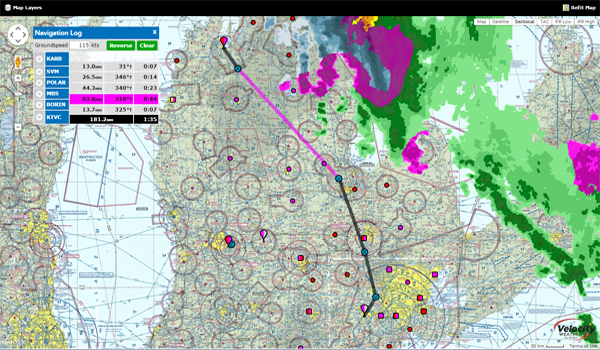
In need of a great resource to get a quick look at a route and the weather and charts along the way? Check out the freely accessible Aviation Charts resource available at iFlightPlanner.com/AviationCharts! No joke. There you'll find the complete set of U.S. Sectional, TAC and IFR Low/High Enroute Charts in the familiar Google Maps interface, updated every 28-days with data direct from the FAA!
It includes the same Map Layers menu used in our Flight Planning Wizard (upper-left corner) to allow you to overlay hi-resolution RADAR and satellite imagery, as well as fuel prices, enroute conditions, graphical AIRMETs, SIGMETs, and features interactive layers for all Special Use Airspace (SUA). You can even share routes with your fellow pilots via email or your favorite social media outlet using the 'Permalink' button!
Wednesday, March 25, 2015
Wednesday, March 25, 2015 @ 8:00 AM
The Pilot’s Handbook of Aeronautical Knowledge (FAA-H-8083-25A) provides basic knowledge that is essential for pilots. This handbook introduces pilots to the broad spectrum of knowledge that will be needed as they progress in their pilot training. Except for the Code of Federal Regulations pertinent to civil aviation, most of the knowledge areas applicable to pilot certification are presented.

This handbook is useful to beginning pilots, as well as those pursuing more advanced pilot certificates and is available for download as a FREE reference via FAA.gov.
Wednesday, March 4, 2015
Wednesday, March 4, 2015 @ 10:31 AM
As described in an earlier iFlightPlanner Blog post, you have the ability to connect connect your iPad to your favorite flight simulator and make iFlightPlanner for iPad behave as if it were flying in the virtual skies with you!
The iFlightPlanner Installation & Setup Guide available in that post was a little soft on the details on how to connect with X-Plane so we're here to offer some clarification for our iFlightPlanner Premium members who are taking advantage of this functionality that's included in their memberships. Know that you will only need to refer to the step-by-step instructions starting on on Page 3, beginning with Step 8, as X-Plane does not require the FSXFlight Plugin.

In X-Plane you will want to go to Settings > Net Connections > iPhone/iPad Tab and select "send AHRS data to ForeFlight, WingX Pro, SkyDemon or FlyQ on ONE iPad or iPhone" or "send AHRS data to ForeFlight, WingX Pro, SkyDemon or FlyQ on ALL iPads or iPhones" (see additional screenshot). If you select "ONE iPad or iPhone, be sure and note the IP address shown in the virtual GPS setting within iFlightPlanner for iPad for the correct IP address. Once in iFlightPlanner for iPad simply select the Simulator GPS setting from the Settings menu and you'll be on your way!
As always, please don't hesitate to let us know if you have any questions. There is a thread in the iFlightPlanner Forums with some great conversation and feedback on how pilots are using iFlightPlanner in the virtual cockpit and we invite you to join in!
The iFlightPlanner Crew
PLAN. FLY. LOG.
Wednesday, January 14, 2015
Wednesday, January 14, 2015 @ 8:00 AM
The iFlightPlanner Crew recently expanded our implementation of Velocity WEATHER by Baron to include the freely accessible aviation charts available online at iFlightPlanner.com/AviationCharts and those found as part of the iFlightPlanner Airport Weather Center and Flight Wizard for registered members.
Available map layers now include hi-resolution RADAR, Infrared and Visible Satellite imagery, all of which can be synchronized for a comprehensive visual representation of current meteorological conditions and match the presentation found in iFlightPlanner for iPad. Use the Map Layers menu in the upper-left corner of the Google Maps interface to access these great new mapping features!

Should you have any questions about this, or any of the features available to you as a Free, Premium or Premium Plus member, please don't hesitate to contact us!
Monday, January 12, 2015
Monday, January 12, 2015 @ 8:00 AM
Wednesday, December 17, 2014
Wednesday, December 17, 2014 @ 8:00 AM
by Russ Niles, AVweb
Assuming Presidential approval, The FAA has funding security for nine months after the Senate passed the so-called "Cromnibus" spending bill that approves appropriations for most government departments through September 2015. The vote on the $1.3 trillion spending bill was held late Saturday and rejects an administration user fee proposal and gives the FAA approximately $440 million more than the administration proposed. The FAA gets $15.72 billion and includes money for NextGen implementation.
The National Air Transportation Association (NATA) stayed up late Saturday night to follow the legislative process and President Tom Hendricks said the relative stability is welcome. "Taking such action funds important priorities such as NextGen and removes the budgetary uncertainty the agency faces when operating under short-term funding bills," said Hendricks.
Monday, December 15, 2014
Monday, December 15, 2014 @ 8:00 AM

Dovetail Games gave flight sim fans a lift for the holiday season with the announcement that Microsoft Flight Simulator X: Steam Edition will launch on December 18 at a spectacular introductory price.
Microsoft Flight Simulator X: Steam Edition delivers an authentically accurate aerial experience for simulation enthusiasts and those with a passion for all things flight. Pilots can climb into the cockpits of over twenty aircraft, from commercial and fighter jets to single-engine private planes and helicopters. More than 80 missions will test players in a variety of ways, including search and rescue challenges, test pilot scenarios, races and more. The game features updated multiplayer functionality, Windows 8.1 support and over 24,000 airports, delivering a beautiful, connected world and vast horizon begging to be explored.
» iFlightPlanner Integration with Microsoft Flight Simulator, X-Plane
Friday, December 12, 2014
Friday, December 12, 2014 @ 8:00 AM
This year the Jardur Watch Company is offering a 20% holiday discount on its premium, Degreemeter model. The Degreemeter is the first aviation chronograph launched under the revitalized Jardur Watch Company, the Degreemeter, pays homage to the original World War II era Bezelmeter 960 while incorporating all of the advancements in materials, manufacturing methods and design features which comprise state-of-the-art watchmaking.
This watch features a degreemeter, unelapsed hours meter, integrated chronograph, date display and non-reflective crystal making it the ultimate pilot's timepiece. The $650 savings is available only to the first 18 customers, and included with the purchase of each watch is one (1) year of iFlightPlanner Premium Plus, an additional $139.99 value!
Visit the iFlightPlanner Shop for more details!

Thursday, December 11, 2014
Thursday, December 11, 2014 @ 4:01 AM
Official airport, navigation and chart data for the FAA's 28-day cycle beginning 12/11/14 became current today as of 09:01Z. This includes updated georeferencing data for airport diagrams and instrument approach procedures available in iFlightPlanner for iPad.
Anytime you access iFlightPlanner.com or mobile.iFlightPlanner.com you can be confident that you are seeing the most current and accurate data available. To ensure that iFlightPlanner for iPad is current, simply tap "Check for Updates" in the upper-left corner of the Downloads tab. The app will quickly tell you which packages need to be updated!
The iFlightPlanner Crew
PLAN. FLY. LOG.
Monday, December 8, 2014
Monday, December 8, 2014 @ 8:00 AM
iFlightPlanner for iPad users may now download airport and navigation data as well as aeronautical charts, airport diagrams and terminal procedures for the FAA Data Cycle that goes into effect on December 11, 2014. Simply tap the button in the upper-left corner of the Downloads tab to "Check For Updates".
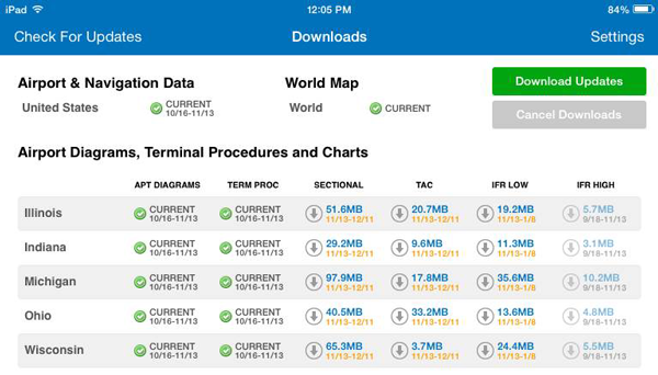
Pilots using iFlightPlanner.com or mobile.iFlightPlanner.com from their smartphones will see the iFlightPlanner Cloud automatically make the transition to the new data at 9:01Z on December 11.
Friday, December 5, 2014
Friday, December 5, 2014 @ 8:00 AM
by Rick Durden, AVweb
 Operation Good Cheer, the annual delivery of donated toys by general aviation aircraft to foster children in Michigan, is short 30 airplanes and pilots of the 100 it needs to get toys to over 5,248 children this Saturday, December 6. Each foster child has a sponsor who has purchased, wrapped and delivered gifts to the Oakland County International Airport (KPTK) where they will be loaded into airplanes flown by volunteer pilots to airports across the state.
Operation Good Cheer is looking for another 30 pilots who have access to aircraft this Saturday and want to play Santa for children who might otherwise not receive gifts at Christmas. Volunteer pilots are asked to complete a Pilot Application at the website of the nonprofit association that organizes the toylift, Child and Family Services of Michigan, or simply fly into KPTK by 8:00 AM Saturday and advise ATC that they are there for Operation Good Cheer.
Monday, December 1, 2014
Monday, December 1, 2014 @ 5:34 PM
Upgrade or extend your iFlightPlanner membership to iFlightPlanner Premium for $69.99 or Premium Plus for $119.99 thru December! That means for less than $10/month you can experience iFlightPlanner Premium Plus, which includes "the best georeferenced airport diagrams and instrument approach procedures available on the iPad" and the fully-integrated flight planning resources at iFlightPlanner.com, for an entire year!

In the middle of your paid subscription with a competitor's flight planning product? No problem! Take advantage of iFlightPlanner's Competitive Trade-Up Program and trade-in your existing subscription. We'll extend your new iFlightPlanner Premium membership by the time remaining on your competitive subscription, up to the length of the iFlightPlanner membership you purchased. Complete details of the program are available at iFlightPlanner.com/Upgrade!
Wednesday, November 26, 2014
Wednesday, November 26, 2014 @ 8:00 AM
 iFlightPlanner, located adjacent to the Ann Arbor Municipal Airport, is now hosting the LiveATC feed for KARB!
The LiveATC network, availabe online at LiveATC.net or through iPhone and Android apps, is the world's largest network of streaming audio feeds focused solely on aviation-related communications, currently covering over 800 airports around the world with over 900 different audio feeds and growing daily!
One of the best resources for improving your radio skills is to listen to LiveATC.net. iFlightPlanner is proud to have partnered with LiveATC to make feeds avialable directly via our Airport/Facility Directory.
» LiveATC at KARB
Friday, November 21, 2014
Friday, November 21, 2014 @ 8:00 AM
Monday, November 17, 2014
Monday, November 17, 2014 @ 8:00 AM
With iFlightPlanner for iPad you now have the ability to connect your iPad to your favorite flight simulator and unleash the best flight planning and in-flight simulation experience anywhere!

Combining iFlightPlanner, FSXFlight and Lockheed Martin Prepar3D, Microsoft Flight Simulator 2004 or Microsoft Flight Simulator X allows pilots of all realms to plan flights using iFlightPlanner and view those routes in iFlightPlanner for iPad for use in their flight simulator. Once in the virtual cockpit, FSXFlight will push all simulated GPS data to iFlightPlanner for iPad via networked WiFi connection and force the iPad to behave as if it were flying in the same airplane!
If you fly with X-Plane, the FSXFlight plugin(s) are not required and you may connect iFlightPlanner for iPad directly to X-Plane over the same wireless network.
» iFlightPlanner Installation & Setup Guide for FSXFlight
» Connecting X-Plane to iFlightPlanner for iPad, The Details
This feature is already available to all iFlightPlanner Premium members and you can upgrade today for as little as $9.99 per month and experience all that iFlightPlanner has to offer!
Thursday, November 13, 2014
Thursday, November 13, 2014 @ 4:01 AM
Official airport, navigation and chart data for the FAA's 56-day cycle beginning 11/13/14 became current today as of 09:01Z. This includes updated georeferencing data for airport diagrams and instrument approach procedures available in iFlightPlanner for iPad.
Anytime you access iFlightPlanner.com or mobile.iFlightPlanner.com you can be confident that you are seeing the most current and accurate data available. To ensure that iFlightPlanner for iPad is current, simply tap "Check for Updates" in the upper-left corner of the Downloads tab. The app will quickly tell you which packages need to be updated!
The iFlightPlanner Crew
PLAN. FLY. LOG.
Wednesday, November 12, 2014
Wednesday, November 12, 2014 @ 8:00 AM
Brought to you by MyGoFlight, this video shows you how to take advantage of a discount that is available through IMC Club's relationship with iFlightPlanner. It is also designed to get pilots to think about redundancy concerning their iPad EFB. A pilot should always have a plan B for the unexpected.
Future Quick Tips will focus on ways pilots can fly more safely using today's technology. For more information on the IMC Clubs and their mission of helping pilots master the art of instrument navigation, visit their website at http://www.IMCclubs.org.
Friday, October 17, 2014
Friday, October 17, 2014 @ 8:00 AM
courtesy MyGoFlight
 Now that we have gone to using electronic charts, where do we find what the various chart symbols mean if we have forgotten what they stand for? It used to be that we would turn the chart over and on the back we would find the symbols and the answer was right there.
The answer to any and all chart symbology questions can be found in a single document from the FAA entitled Aeronautical Chart User's Guide. This guide provides an explanation of all VFR and IFR chart terms and symbols and can be found on the FAA website page of digital products.
» Aeronautical Chart User's Guide
Wednesday, October 15, 2014
Wednesday, October 15, 2014 @ 8:00 AM
Wednesday, October 8, 2014
Wednesday, October 8, 2014 @ 8:00 AM
courtesy AERO-NEWS
 Most Federal Aviation Regulations make sense because they are aimed at aviation safety. Some of the safety related rules may seem arbitrary, but they are intended to establish minimum safety standards. Other rules may not be safety related are usually rules that require pilots to show compliance with the regulations. When we use the term ramp check, we are not talking about the unfortunate cases of pilots being approached and questioned by military uniformed personnel from various government agencies. What we are reviewing is the simple case of an FAA operations inspectors walking up in civilian clothes, shaking your hand, and announcing that you’re about to receive a ramp check.
The purpose of the ramp check is to verify that the pilot and aircraft are in compliance with the certification regulations. In other words, your paperwork had better be in order. Pilots and aircraft must have certain paperwork to be legal to fly. If you want the actual details of what the FAA inspector is authorized to do on a ramp check, it’s found in FAA Order 8900.1, Chapter 1, Section 4, titled Conduct a FAR Part 91 Ramp Inspection.
The pilot must have the following items in his or her possession and must present them upon request by an FAA or law enforcement official.
- FAA Pilot Certificate
- Government Issued Photo ID (i.e., state driver’s license)
- Proof of Medical Certification - for a sport pilot or sport pilot student, this could be an FAA medical certificate or a valid state driver’s license
A student pilot must have his or her logbook on cross country flights, and a sport pilot must have either his or her logbook with the appropriate sport pilot endorsements or a record of the endorsements. Recreational pilots must also have proof of endorsement for extended cross-country flying and tower controlled airspace training if they had received those endorsements.
Private and higher-rated pilots are not required to carry logbooks with them, and that’s probably a pretty good idea. However the FAA inspector may ask you to present some sort of proof of appropriate endorsements, such as a flight review, within a reasonable period of time.
The aircraft must also have certain papers to be legal to operate.
- Airworthiness Certificate - onboard and visible
- Registration Certificate - onboard with correct address and ownership information on record with the FAA
- Operating Limitations - onboard the aircraft as part of the aircraft operating handbook, separate document or placards
With a little preparation and a calm demeanor, receiving a ramp check is not that big of a deal.
