Wednesday, August 17, 2016
Wednesday, August 17, 2016 @ 8:00 AM
The FAA has again delayed the implementation of the international flight plan form (ICAO) for all civil domestic flights. Barring another postponement, the FAA will eliminate use of the domestic format flight plan and make the transition to ICAO format in January 2017.
ICAO flight plans contain specific information relating to the proposed flight of an aircraft and controllers use them to provide air traffic services based on the capabilities of each aircraft. Today pilots file flight plans in the U.S. under either the domestic or ICAO format, and the use of one format will simplify the process and align U.S. flight plans with ICAO standards.
This flight planning QuickTip will show you how to easily update your iFlightPlanner aircraft profiles and enjoy a seamless transition to the new ICAO flight plan format when creating and filing flight plans with iFlightPlanner. iFlightPlanner is, and has been ready since this change was first proposed in 2012!
As referenced in the video, there is a lot of aircraft-specific information required to file the ICAO flight plans. However, if you are only flying domestically the FAA requires less ICAO data.
The FAA has issued an informal guidance document that highlights changes specific to the international flight plan form that pertain exclusively to flight within the National Airspace System.

Should you have any questions specific to filing ICAO flight plans in iFlightPlanner, please don't hesitate to contact us!
The iFlightPlanner Crew
PLAN. FLY. LOG.
Monday, August 15, 2016
Monday, August 15, 2016 @ 8:00 AM
iFlightPlanner for iPad users may now download airport and navigation data as well as aeronautical charts, georeferenced airport diagrams and terminal procedures for the FAA Data Cycle that goes into effect on August 18, 2016. Simply tap the button in the upper-left corner of the Downloads tab to "Check For Updates".
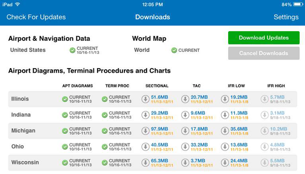
Pilots using iFlightPlanner.com or mobile.iFlightPlanner.com from their smartphones will see the iFlightPlanner Cloud automatically make the transition to the new data at 9:01Z on August 18.
Monday, July 25, 2016
Monday, July 25, 2016 @ 8:00 AM
The FAR-FC and FAR-AMT books are available and shipping now from ASA. The FAR/AIM (which includes new 14 CFR Parts 48 and 107 pertaining to both manned aircraft and remote pilot operations) will begin shipping on August 10.

The ASA FAR/AIM Series books are indexed and show clearly-marked changes since the last release for quick reference.
Thursday, July 21, 2016
Thursday, July 21, 2016 @ 4:01 AM
 Official airport, navigation and chart data for the FAA's 56-day cycle beginning 7/21/16 became current today as of 09:01Z. This includes updated georeferenced data for airport diagrams and instrument approach procedures available in iFlightPlanner for iPad.
Anytime you access iFlightPlanner.com or mobile.iFlightPlanner.com you can be confident that you are seeing the most current and accurate data available. To ensure that iFlightPlanner for iPad is current, simply tap "Check for Updates" in the upper-left corner of the Downloads tab. The app will quickly tell you which packages need to be updated!
The iFlightPlanner Crew
PLAN. FLY. LOG.
Wednesday, July 20, 2016
Wednesday, July 20, 2016 @ 8:00 AM
The 2016 AirVenture NOTAM specifies sign codes used to inform ground personnel of your desired parking area at Wittman Regional Airport. You'll need to display one of these signs for your arrival and another for departure based on your aircraft type and parking or camping preference.

Arrival Signs
Departure Signs
The AirVenture NOTAM is required reading and should be part of every pilot's preflight preparation. Remember to print your arrival and departure signs before your trip and fly safe!
The iFlightPlanner Crew
PLAN. FLY. LOG.
Monday, July 18, 2016
Monday, July 18, 2016 @ 8:00 AM
iFlightPlanner for iPad users may now download airport and navigation data as well as aeronautical charts, georeferenced airport diagrams and terminal procedures for the FAA Data Cycle that goes into effect on July 21, 2016. Simply tap the button in the upper-left corner of the Downloads tab to "Check For Updates".
Pilots using iFlightPlanner.com or mobile.iFlightPlanner.com from their smartphones will see the iFlightPlanner Cloud automatically make the transition to the new data at 9:01Z on July 21.
Thursday, June 23, 2016
Thursday, June 23, 2016 @ 4:01 AM
Official airport, navigation and chart data for the FAA's 28-day cycle beginning 6/23/16 became current today as of 09:01Z. This includes updated georeferenced data for airport diagrams and instrument approach procedures available in iFlightPlanner for iPad.
Anytime you access iFlightPlanner.com or mobile.iFlightPlanner.com you can be confident that you are seeing the most current and accurate data available. To ensure that iFlightPlanner for iPad is current, simply tap "Check for Updates" in the upper-left corner of the Downloads tab. The app will quickly tell you which packages need to be updated!
The iFlightPlanner Crew
PLAN. FLY. LOG.
Monday, June 20, 2016
Monday, June 20, 2016 @ 8:00 AM
iFlightPlanner for iPad users may now download airport and navigation data as well as aeronautical charts, georeferenced airport diagrams and terminal procedures for the FAA Data Cycle that goes into effect on June 23, 2016. Simply tap the button in the upper-left corner of the Downloads tab to "Check For Updates".
Pilots using iFlightPlanner.com or mobile.iFlightPlanner.com from their smartphones will see the iFlightPlanner Cloud automatically make the transition to the new data at 9:01Z on June 23.
Thursday, May 26, 2016
Thursday, May 26, 2016 @ 4:01 AM
Official airport, navigation and chart data for the FAA's 56-day cycle beginning 5/26/16 became current today as of 09:01Z. This includes updated georeferenced data for airport diagrams and instrument approach procedures available in iFlightPlanner for iPad.
Anytime you access iFlightPlanner.com or mobile.iFlightPlanner.com you can be confident that you are seeing the most current and accurate data available. To ensure that iFlightPlanner for iPad is current, simply tap "Check for Updates" in the upper-left corner of the Downloads tab. The app will quickly tell you which packages need to be updated!
The iFlightPlanner Crew
PLAN. FLY. LOG.
Monday, May 23, 2016
Monday, May 23, 2016 @ 8:00 AM
iFlightPlanner for iPad users may now download airport and navigation data as well as aeronautical charts, georeferenced airport diagrams and terminal procedures for the FAA Data Cycle that goes into effect on May 26, 2016. Simply tap the button in the upper-left corner of the Downloads tab to "Check For Updates".
Pilots using iFlightPlanner.com or mobile.iFlightPlanner.com from their smartphones will see the iFlightPlanner Cloud automatically make the transition to the new data at 9:01Z on May 26.
Thursday, April 28, 2016
Thursday, April 28, 2016 @ 4:01 AM
Official airport, navigation and chart data for the FAA's 28-day cycle beginning 4/28/16 became current today as of 09:01Z. This includes updated georeferenced data for airport diagrams and instrument approach procedures available in iFlightPlanner for iPad.
Anytime you access iFlightPlanner.com or mobile.iFlightPlanner.com you can be confident that you are seeing the most current and accurate data available. To ensure that iFlightPlanner for iPad is current, simply tap "Check for Updates" in the upper-left corner of the Downloads tab. The app will quickly tell you which packages need to be updated!
The iFlightPlanner Crew
PLAN. FLY. LOG.
Monday, April 25, 2016
Monday, April 25, 2016 @ 8:00 AM
iFlightPlanner for iPad users may now download airport and navigation data as well as aeronautical charts, georeferenced airport diagrams and terminal procedures for the FAA Data Cycle that goes into effect on April 28, 2016. Simply tap the button in the upper-left corner of the Downloads tab to "Check For Updates".
Pilots using iFlightPlanner.com or mobile.iFlightPlanner.com from their smartphones will see the iFlightPlanner Cloud automatically make the transition to the new data at 9:01Z on April 28.
Friday, April 15, 2016
Friday, April 15, 2016 @ 8:00 AM
Search by aircraft make and model in this FAA database of ADS-B equipment designed to meet the requirements of 14 CFR 91.225 and 91.227, either as separate components or complete installation solutions. The database includes both FAA-certified equipment and equipment not yet approved. See Definitions Legend at the bottom of the page for additional details.

» ADS-B Compliant Equipment Search Tool
Wednesday, April 13, 2016
Wednesday, April 13, 2016 @ 8:00 AM
 The FAA issued two direct-to-final-rule Airworthiness Directives this week that affect nearly 6,000 general aviation aircraft.
An Airworthiness Directive (AD) for Cessna addresses the elevator trim tabs in roughly 5,000 twin-engine T310Q, 310Q, and 402B aircraft. Textron already has issued a service bulletin and the FAA is allowing 90 days for owners to make the fix, with the clock starting on April 26. Replacing the elevator trim push-pull rod hardware should cost around $100, the FAA said.
The Piper AD addresses reports of rib cracks found in the wings of PA-28 Cherokees that occurred during production, and extends a previous directive to include upwards of 700 aircraft. Per the FAA, operators should expect to pay $85 for an inspection and $125 if repairs are needed. If not corrected, could result in reduced structural integrity of the wing. Operators must comply with the AD within 25 hours of flying after the effective date of April 26, with the exception of those airplanes listed in the previous AD, which have 25 hours after last October 29 to comply.
Monday, April 11, 2016
Monday, April 11, 2016 @ 8:00 AM
GPS testing scheduled for April 11-15, 18-23, and 25-29 may result in unreliable or unavailable GPS signals in the Midwest per Flight Advisory GAFC 16-02.
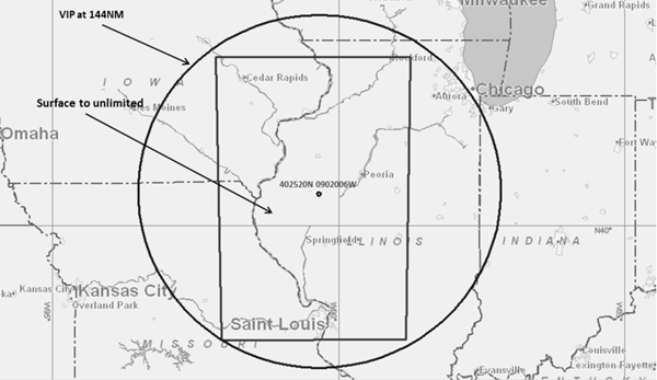
The location of the testing is centered at 402520N/902006W or the Spinner VORTAC (SPI) 321 degree radial at 46NM and will occur at the following dates and times:
- 11–15 APR 16 1300Z – 2100Z
- 18–23 APR 16 1300Z – 2100Z
- 25–29 APR 16 1300Z – 2100Z
The NOTAMs discussed in this advisory may change with little or no notice, and the FAA encourages pilots to check NOTAMs frequently for possible changes prior to operations in the area which will be published at least 24 hours in advance of any GPS tests.
» Flight Advisory GAFC 16-02
Thursday, March 31, 2016
Thursday, March 31, 2016 @ 4:01 AM
Official airport, navigation and chart data for the FAA's 56-day cycle beginning 3/31/16 became current today as of 09:01Z. This includes updated georeferenced data for airport diagrams and instrument approach procedures available in iFlightPlanner for iPad.
Anytime you access iFlightPlanner.com or mobile.iFlightPlanner.com you can be confident that you are seeing the most current and accurate data available. To ensure that iFlightPlanner for iPad is current, simply tap "Check for Updates" in the upper-left corner of the Downloads tab. The app will quickly tell you which packages need to be updated!
The iFlightPlanner Crew
PLAN. FLY. LOG.
Monday, March 28, 2016
Monday, March 28, 2016 @ 8:00 AM
iFlightPlanner for iPad users may now download airport and navigation data as well as aeronautical charts, georeferenced airport diagrams and terminal procedures for the FAA Data Cycle that goes into effect on March 31, 2016. Simply tap the button in the upper-left corner of the Downloads tab to "Check For Updates".
Pilots using iFlightPlanner.com or mobile.iFlightPlanner.com from their smartphones will see the iFlightPlanner Cloud automatically make the transition to the new data at 9:01Z on March 31.
Friday, March 18, 2016
Friday, March 18, 2016 @ 8:00 AM
GPS testing scheduled for March 21, 30, and 31 may result in unreliable or unavailable GPS signals on the east coast per Flight Advisory CSG4 GPS 16-01.

The location of the testing is centered at 322655N0793719W or the Charleston VORTAC (CHS) 150 degree radial at 34NM and will occur on March 21 from 1100-1900Z, and March 30-31 from 1100-1700Z.
The NOTAMs discussed in this advisory may change with little or no notice, and the FAA encourages pilots to check NOTAMs frequently for possible changes prior to operations in the area which will be published at least 24 hours in advance of any GPS tests.
» Flight Advisory CSG4 GPS 16-01
Wednesday, March 16, 2016
Wednesday, March 16, 2016 @ 8:00 AM
While all of the information provided in the publication will remain the same, the FAA’s familiar green Airport/Facility Directory is changing its official name with the March 31 editions to the "Chart Supplement" per a Charting Notice dated March 31, 2016.

The newly named supplements for the lower 48 states, Puerto Rico, and the U.S. Virgin Islands will continue to contain complete airport data highlighting navigation, communication, weather sources, runways, obstacles, and other information necessary for safe flight. The FAA said the change will bring the Airport/Facility Directory in line with Interagency Air Cartographic (AICC) 8 specifications for printed products. Additionally, all knowledge tests, literature, and other references will soon reflect the new name, which has already been implemented for the country’s northwest region.
The change will not effect the Airport/Facility Directory available online at iFlightPlanner.com/Airports or in iFlightPlanner for iPad.
Monday, February 29, 2016
Monday, February 29, 2016 @ 8:00 AM
iFlightPlanner for iPad users may now download airport and navigation data as well as aeronautical charts, georeferenced airport diagrams and terminal procedures for the FAA Data Cycle that goes into effect on March 3, 2016. Simply tap the button in the upper-left corner of the Downloads tab to "Check For Updates".
Pilots using iFlightPlanner.com or mobile.iFlightPlanner.com from their smartphones will see the iFlightPlanner Cloud automatically make the transition to the new data at 9:01Z on March 3.
Monday, February 1, 2016
Monday, February 1, 2016 @ 8:00 AM
iFlightPlanner for iPad users may now download airport and navigation data as well as aeronautical charts, georeferenced airport diagrams and terminal procedures for the FAA Data Cycle that goes into effect on February 4, 2016. Simply tap the button in the upper-left corner of the Downloads tab to "Check For Updates".
Pilots using iFlightPlanner.com or mobile.iFlightPlanner.com from their smartphones will see the iFlightPlanner Cloud automatically make the transition to the new data at 9:01Z on February 4.
Wednesday, January 13, 2016
Wednesday, January 13, 2016 @ 8:00 AM
 Under a new rule released by the FAA, student pilots will no longer get their student pilot certificate from an aviation medical examiner. Instead, they can apply in person at a FSDO, through a designated pilot examiner, with a Part 141 flight school or a CFI. The TSA will vet the application, and then a plastic certificate will be sent to the student by the Civil Aviation Registry.
Student pilots who already have a paper certificate can continue to use it until it expires, according to the new rule which began with an NPRM issued in November 2010. The FAA received about 470 comments on that proposal.
Monday, January 11, 2016
Monday, January 11, 2016 @ 8:00 AM
The FAA is considering a request from the 180th Fighter Wing of the Ohio Air National Guard to establish the Stinger Temporary Military Operations Area (MOA). This new MOA would provide airspace support for rapid ingress and egress of clean configured aircraft into and out of the area for Exercise Solemn Stinger.

The proposed temporary MOA would be effective from June 7 to August 6, 2016, five days per week, not to exceed 45 days total, from 0930-1100 and 1330-1500, Tuesday through Saturday by NOTAM four hours in advance.
Execution of missions will be from Toledo Air National Guard Base (KTOL) in Swanton, Ohio. A maximum of eight F-16 sorties per day will be performed during the exercise from 6,000 feet MSL up to, but not including, 18,000 feet MSL.
Members who wish to comment on the proposal may send them to 9-NATL-CSA-Public-Notice-Airspace@faa.gov. Comments must be received on or before February 1, 2016.
Friday, January 8, 2016
Friday, January 8, 2016 @ 8:00 AM
The FAA will be applying additional flight restrictions to the Washington, D.C. Special Flight Rules Area (SFRA) and Flight Restricted Zone (FRZ) for President Obama’s State of the Union address on January 12. Click the image for an interactive map of the changes.

Pilots in the Washington, D.C. area are urged to read the flight advisory issued by the FAA, which describes the additional restrictions in more detail.
Thursday, January 7, 2016
Thursday, January 7, 2016 @ 4:01 AM
Official airport, navigation and chart data for the FAA's 28-day cycle beginning 1/7/16 became current today as of 09:01Z. This includes updated georeferenced data for airport diagrams and instrument approach procedures available in iFlightPlanner for iPad.
Anytime you access iFlightPlanner.com or mobile.iFlightPlanner.com you can be confident that you are seeing the most current and accurate data available. To ensure that iFlightPlanner for iPad is current, simply tap "Check for Updates" in the upper-left corner of the Downloads tab. The app will quickly tell you which packages need to be updated!
The iFlightPlanner Crew
PLAN. FLY. LOG.
Monday, January 4, 2016
Monday, January 4, 2016 @ 8:00 AM
iFlightPlanner for iPad users may now download airport and navigation data as well as aeronautical charts, georeferenced airport diagrams and terminal procedures for the FAA Data Cycle that goes into effect on January 7, 2016. Simply tap the button in the upper-left corner of the Downloads tab to "Check For Updates".
Pilots using iFlightPlanner.com or mobile.iFlightPlanner.com from their smartphones will see the iFlightPlanner Cloud automatically make the transition to the new data at 9:01Z on January 7.
Wednesday, December 30, 2015
Wednesday, December 30, 2015 @ 8:00 AM
The FAA is seeking comments on two draft advisory circulars (ACs), AC 00-45H and AC 00-6B, that update the agency’s reference material on aviation weather. The new drafts would replace weather guidance dating to 1943. The weather guidance was completely rewritten in 1975, and updated again in 2015.
“Basic weather science has not changed significantly since 1975. However, new capabilities now necessitate the incorporation of new science. In 1975, aviation users were not directly touched by radar and satellite weather. In 2015, much of what a pilot understands about the current atmosphere comes from these ubiquitous data sources,” the FAA said.
To review the new documents and submit comments by January 20, visit this page on the FAA website, where the individual email and mailing addresses for sending comments on the drafts are provided.
Wednesday, December 16, 2015
Wednesday, December 16, 2015 @ 8:00 AM
The FAA recently issued a revised Advisory Circular 70/7460-1L that updates guidelines for the proper way to light and mark obstructions affecting navigable airspace.
Among the changes include the requirement for the FAA to determine whether a structure that is 200 feet above ground level (AGL) or higher, or near an airport, does not pose an airspace hazard. Also included are new lighting specifications for wind turbines, new lighting and marking standards for reducing the impact on migratory bird populations, and standards for voluntary marking of meteorological evaluation towers lower than 200 feet.
» Advisory Circular AC 70/7460-1L
Thursday, December 10, 2015
Thursday, December 10, 2015 @ 4:01 AM
Official airport, navigation and chart data for the FAA's 56-day cycle beginning 12/10/15 became current today as of 09:01Z. This includes updated georeferenced data for airport diagrams and instrument approach procedures available in iFlightPlanner for iPad.
Anytime you access iFlightPlanner.com or mobile.iFlightPlanner.com you can be confident that you are seeing the most current and accurate data available. To ensure that iFlightPlanner for iPad is current, simply tap "Check for Updates" in the upper-left corner of the Downloads tab. The app will quickly tell you which packages need to be updated!
The iFlightPlanner Crew
PLAN. FLY. LOG.
Monday, December 7, 2015
Monday, December 7, 2015 @ 8:00 AM
iFlightPlanner for iPad users may now download airport and navigation data as well as aeronautical charts, georeferenced airport diagrams and terminal procedures for the FAA Data Cycle that goes into effect on December 10, 2015. Simply tap the button in the upper-left corner of the Downloads tab to "Check For Updates".
Pilots using iFlightPlanner.com or mobile.iFlightPlanner.com from their smartphones will see the iFlightPlanner Cloud automatically make the transition to the new data at 9:01Z on December 10.
Thursday, November 12, 2015
Thursday, November 12, 2015 @ 4:01 AM
Official airport, navigation and chart data for the FAA's 28-day cycle beginning 11/12/15 became current today as of 09:01Z. This includes updated georeferenced data for airport diagrams and instrument approach procedures available in iFlightPlanner for iPad.
Anytime you access iFlightPlanner.com or mobile.iFlightPlanner.com you can be confident that you are seeing the most current and accurate data available. To ensure that iFlightPlanner for iPad is current, simply tap "Check for Updates" in the upper-left corner of the Downloads tab. The app will quickly tell you which packages need to be updated!
The iFlightPlanner Crew
PLAN. FLY. LOG.
Monday, November 9, 2015
Monday, November 9, 2015 @ 8:00 AM
 The FAA has announced a new plan to ensure that pilots have all the information they need as the agency phases out world aeronautical charts (WACs), with new Alaska and Caribbean charts being created to fill the gaps.
In an October 29 announcement, the FAA said it will produce an Alaska VFR Wall Planning Chart to help pilots as they plan long-distance flights. The wall chart will show all of Alaska as well as the Canadian territory between Washington State and Alaska. The FAA also will produce two new Caribbean VFR Aeronautical Charts that will provide more coverage than is available with the three WACs they will replace. The scale for the Caribbean charts will be 1 to 1 million.
The new charts should be available in early January 2017, when the existing WACs for those areas expire.
» Read more on AOPA.org
Monday, November 9, 2015 @ 4:01 AM
iFlightPlanner for iPad users may now download airport and navigation data as well as aeronautical charts, georeferenced airport diagrams and terminal procedures for the FAA Data Cycle that goes into effect on November 12, 2015. Simply tap the button in the upper-left corner of the Downloads tab to "Check For Updates".
Pilots using iFlightPlanner.com or mobile.iFlightPlanner.com from their smartphones will see the iFlightPlanner Cloud automatically make the transition to the new data at 9:01Z on November 12.
Thursday, October 15, 2015
Thursday, October 15, 2015 @ 8:00 AM
Official airport, navigation and chart data for the FAA's 56-day cycle beginning 10/15/15 became current today as of 09:01Z. This includes updated georeferenced data for airport diagrams and instrument approach procedures available in iFlightPlanner for iPad.
Anytime you access iFlightPlanner.com or mobile.iFlightPlanner.com you can be confident that you are seeing the most current and accurate data available. To ensure that iFlightPlanner for iPad is current, simply tap "Check for Updates" in the upper-left corner of the Downloads tab. The app will quickly tell you which packages need to be updated!
The iFlightPlanner Crew
PLAN. FLY. LOG.
Wednesday, October 14, 2015
Wednesday, October 14, 2015 @ 8:00 AM
By Dan Namowitz, AOPA
 The National Weather Service said the weather product, long familiar to pilots as a major component of preflight weather briefings, will be discontinued for the continental United States and Hawaii in the second half of 2016. Area forecasts will continue to be issued for Alaska, the Caribbean, and the Gulf of Mexico.
The FAA, in a June 2014 Federal Register notice of a proposed transition to digital and graphical alternatives, explained that area forecasts “tend to produce a broad forecast of limited value. While the Area Forecast (FA) met aviation weather information needs for many years, today NWS provides equivalent information through a number of better alternatives.”
» Read More
Monday, October 12, 2015
Monday, October 12, 2015 @ 8:00 AM
iFlightPlanner for iPad users may now download airport and navigation data as well as aeronautical charts, georeferenced airport diagrams and terminal procedures for the FAA Data Cycle that goes into effect on October 15, 2015. Simply tap the button in the upper-left corner of the Downloads tab to "Check For Updates".
Pilots using iFlightPlanner.com or mobile.iFlightPlanner.com from their smartphones will see the iFlightPlanner Cloud automatically make the transition to the new data at 9:01Z on October 15.
Monday, September 21, 2015
Monday, September 21, 2015 @ 8:00 AM
 The FAA has issued flight advisories detailing temporary flight restrictions (TFRs) in the vicinities of New York, Philadelphia and Washington D.C., to enable Pope Francis' scheduled visits to each city.
The FAA has issued a flight advisory for the papal visit to Washington, D.C., September 22-24. It alerts pilots that notams will be issued to modify the Washington, D.C., Special Flight Rules Area and Flight Restricted Zone with additional flight restrictions. The modifications will include the suspension of most flight waivers to operate within the flight restricted zone and Prohibited Area P-56.
The flight advisory also notes that "absolutely no drones are permitted within the Washington D.C. temporary flight restrictions."
Friday, September 11, 2015
Friday, September 11, 2015 @ 8:00 AM
Reacting to complaints from pilots and general aviation groups, the FAA has rescinded a NOTAM published at the start of September.
In its place the FAA is publishing new NOTAMs that specify locations, altitudes, timeframes and equipment affected. The FAA may issue more notices between now and the beginning of October warning of similar activity, according to the Experimental Aircraft Association, which along with AOPA voiced concerns about the vague nature of the notam published at the start of the September.
Friday, September 4, 2015
Friday, September 4, 2015 @ 8:00 AM
UPDATE: FAA Rescinds Southeast ADS-B Notam
The FAA is warning pilots flying in the Southeast that ADS-B and TCAS traffic avoidance technology will be disrupted the entire month of September from Virginia to Florida because of "military activities."
ZNY NOTAM 5/2817 states that TCAS might fail to establish tracks on nearby aircraft and may not see aircraft that would normally trigger a TCAS resolution. False alerts, however, are not expected to be triggered during the exercise. The FAA is advising pilots flying in the affected area to "maintain increased visual awareness" and to treat all traffic alerts as real.
Wednesday, September 2, 2015
Wednesday, September 2, 2015 @ 8:00 AM
The FAA will discontinue the use of the dedicated Flight Watch radio frequency 122.0 MHz on September 24, a week earlier than the previously announced end date for the En Route Flight Advisory Service (EFAS) frequency.
The FAA changed the implementation date to September 24 from October 1 because all necessary preparations will be completed earlier than planned. Services provided by EFAS will continue to be offered over published Flight Service frequencies and on 122.2 MHz, the universal frequency for contacting Flight Service.
After its discontinuation, 122.0 MHz will be monitored for six months so pilots may be directed to other frequencies appropriate for their flight.
Friday, August 21, 2015
Friday, August 21, 2015 @ 8:00 AM
UPDATE: FAA Ending Universal Flight Watch Weather Frequency on 9/24
The FAA will discontinue the universal Flight Watch frequency 122.0 MHz for in-flight weather services on October 1. Weather services provided under the Flight Watch program Enroute Flight Advisory Service (EFAS) will continue to be provided via charted frequencies pilots use to obtain weather information, open and close flight plans, and for updates on notams and temporary flight restrictions.
The changes come as pilots transition "from traditional Flight Service assistance to more automated and web-based tools to obtain services. Through the use of updated technology Flight Service is taking the opportunity to eliminate redundancies and underutilized services," the FAA informed pilots in a message on its website.
Providing the weather services on local flight service frequencies will resolve issues of bleed-over and frequency congestion that have occurred on 122.0 MHz. Another advantage of the change will be the availability of the services on Flight Service frequencies monitored 24 hours a day, seven days a week, as opposed to the limited monitoring of 122.0 MHz, said Rune Duke, AOPA director of government affairs for airspace and air traffic.
After October 1, the FAA will continue to monitor 122.0 MHz for several months to assist pilots in locating a local frequency.
Thursday, August 20, 2015
Thursday, August 20, 2015 @ 4:01 AM
Official airport, navigation and chart data for the FAA's 56-day cycle beginning 8/20/15 became current today as of 09:01Z. This includes updated georeferenced data for airport diagrams and instrument approach procedures available in iFlightPlanner for iPad.
Anytime you access iFlightPlanner.com or mobile.iFlightPlanner.com you can be confident that you are seeing the most current and accurate data available. To ensure that iFlightPlanner for iPad is current, simply tap "Check for Updates" in the upper-left corner of the Downloads tab. The app will quickly tell you which packages need to be updated!
The iFlightPlanner Crew
PLAN. FLY. LOG.
Thursday, July 23, 2015
Thursday, July 23, 2015 @ 4:01 AM
Official airport, navigation and chart data for the FAA's 28-day cycle beginning 7/23/15 became current today as of 09:01Z. This includes updated georeferenced data for airport diagrams and instrument approach procedures available in iFlightPlanner for iPad.
Anytime you access iFlightPlanner.com or mobile.iFlightPlanner.com you can be confident that you are seeing the most current and accurate data available. To ensure that iFlightPlanner for iPad is current, simply tap "Check for Updates" in the upper-left corner of the Downloads tab. The app will quickly tell you which packages need to be updated!
The iFlightPlanner Crew
PLAN. FLY. LOG.
Monday, July 20, 2015
Monday, July 20, 2015 @ 8:00 AM
iFlightPlanner for iPad users may now download airport and navigation data as well as aeronautical charts, georeferenced airport diagrams and terminal procedures for the FAA Data Cycle that goes into effect on July 23, 2015. Simply tap the button in the upper-left corner of the Downloads tab to "Check For Updates".
Pilots using iFlightPlanner.com or mobile.iFlightPlanner.com from their smartphones will see the iFlightPlanner Cloud automatically make the transition to the new data at 9:01Z on July 23.
Wednesday, July 15, 2015
Wednesday, July 15, 2015 @ 8:00 AM
 This free 32-page booklet is an absolute must if you're flying an aircraft to Oshkosh. The AirVenture 2015 NOTAM outlines all arrival/departure procedures, radio frequencies, Wittman Regional Airport (KOSH) details, and much more. Although many of the procedures are similar to previous years, there are updates in nearly every area to enhance safety, efficiency, and convenience for the thousands of airplanes expected at the World's Greatest Aviation Celebration.
The EAA AirVenture NOTAM is required reading and should be part of every pilot's preflight preparation. Remember to print your arrival and departure signs before your trip and fly safe!
The iFlightPlanner Crew
PLAN. FLY. LOG.
Wednesday, July 1, 2015
Wednesday, July 1, 2015 @ 8:00 AM
We are pleased to report that the bug in iOS 8.3 that blocked GPS position data from Bluetooth GPS devices has been resolved with the release of iOS 8.4.
The problem affected the XGPS150, XGPS160 and XGPS170 from Dual as well as Bluetooth GPS devices from other manufacturers such as Bad Elf and Garmin. Our in-house testing has confirmed that the devices are now working properly.

We want to thank our membership for your patience during the past three months as we know how frustrating this was. Should you have any questions please do not hesitate to contact us, we are always happy to help!
Thursday, June 25, 2015
Thursday, June 25, 2015 @ 4:01 AM
Official airport, navigation and chart data for the FAA's 56-day cycle beginning 6/25/15 became current today as of 09:01Z. This includes updated georeferenced data for airport diagrams and instrument approach procedures available in iFlightPlanner for iPad.
Anytime you access iFlightPlanner.com or mobile.iFlightPlanner.com you can be confident that you are seeing the most current and accurate data available. To ensure that iFlightPlanner for iPad is current, simply tap "Check for Updates" in the upper-left corner of the Downloads tab. The app will quickly tell you which packages need to be updated!
The iFlightPlanner Crew
PLAN. FLY. LOG.
Monday, June 22, 2015
Monday, June 22, 2015 @ 8:00 AM
iFlightPlanner for iPad users may now download airport and navigation data as well as aeronautical charts, georeferenced airport diagrams and terminal procedures for the FAA Data Cycle that goes into effect on June 25, 2015. Simply tap the button in the upper-left corner of the Downloads tab to "Check For Updates".
Pilots using iFlightPlanner.com or mobile.iFlightPlanner.com from their smartphones will see the iFlightPlanner Cloud automatically make the transition to the new data at 9:01Z on June 25.
Wednesday, June 10, 2015
Wednesday, June 10, 2015 @ 8:00 AM
During Apple's Worldwide Developer Conference (WWDC) keynote yesterday, Apple announced iOS 8.4 which is expected to be available by June 30th and include a fix for the bug affecting external GPS receiver accessories.

Although everyone, including the elves at Bad Elf, had hoped for a 8.3.1 update or 8.4 release to launch much sooner there is confidence in the fact that a firm date has finally been announced.
» More at BadElf.com
Thursday, May 28, 2015
Thursday, May 28, 2015 @ 4:01 AM
Official airport, navigation and chart data for the FAA's 28-day cycle beginning 5/28/15 became current today as of 09:01Z. This includes updated georeferenced data for airport diagrams and instrument approach procedures available in iFlightPlanner for iPad.
Anytime you access iFlightPlanner.com or mobile.iFlightPlanner.com you can be confident that you are seeing the most current and accurate data available. To ensure that iFlightPlanner for iPad is current, simply tap "Check for Updates" in the upper-left corner of the Downloads tab. The app will quickly tell you which packages need to be updated!
The iFlightPlanner Crew
PLAN. FLY. LOG.
